IMAGES TAKEN NEAR TO
Long Lane, DOVER, CT15 7LX
Introduction
This page details the photographs taken nearby to Long Lane, CT15 7LX by members of the Geograph project.
The Geograph project started in 2005 with the aim of publishing, organising and preserving representative images for every square kilometre of Great Britain, Ireland and the Isle of Man.

There are currently over 7.5m images from over14,400 individuals and you can help contribute to the project by visiting https://www.geograph.org.uk
Image Map
Images are licensed for reuse under creativecommons.org/licenses/by-sa/2.0
Notes
- Clicking on the map will re-center to the selected point.
- The higher the marker number, the further away the image location is from the centre of the postcode.
Image Listing (42 Images Found)
Images are licensed for reuse under creativecommons.org/licenses/by-sa/2.0
Image
Details
Distance
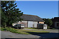
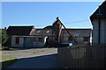
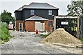
4
Long Lane Farm
Viewed across wheat field from Eythorne Road.
Image: © Oast House Archive
Taken: 17 Jul 2010
0.02 miles
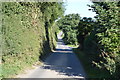
6
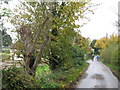
Long Lane past Long Lane Farm
This lane leads from Golgotha towards West Court Downs Lane.
This lane is also used by the North Downs Way (long distance path) between Shepherdswell to Woolage Village.
Image: © David Anstiss
Taken: 31 Oct 2010
0.03 miles
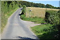
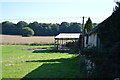
10
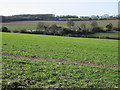
View across the fields towards Long Lane Farm
Image: © Nick Smith
Taken: 6 Jan 2008
0.06 miles