IMAGES TAKEN NEAR TO
The Close, DOVER, CT15 7LD
Introduction
This page details the photographs taken nearby to The Close, CT15 7LD by members of the Geograph project.
The Geograph project started in 2005 with the aim of publishing, organising and preserving representative images for every square kilometre of Great Britain, Ireland and the Isle of Man.

There are currently over 7.5m images from over14,400 individuals and you can help contribute to the project by visiting https://www.geograph.org.uk
Image Map
Images are licensed for reuse under creativecommons.org/licenses/by-sa/2.0
Notes
- Clicking on the map will re-center to the selected point.
- The higher the marker number, the further away the image location is from the centre of the postcode.
Image Listing (50 Images Found)
Images are licensed for reuse under creativecommons.org/licenses/by-sa/2.0
Image
Details
Distance
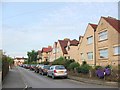
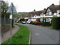
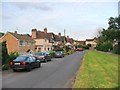
7
One of the entrances to The Close, Lydden
Image: © Nick Smith
Taken: 25 Apr 2008
0.06 miles
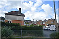
8
Lydden County Primary School, Stonehall Road
Dover District Council has raised no objection under application number DOV/21/00956 for the “demolition of existing school hall and replacement with new school hall linked to existing building, formation of new vehicular access and staff car park”
Image: © John Baker
Taken: 17 Jul 2021
0.08 miles
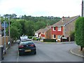
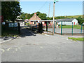
10
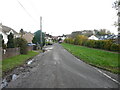
Stonehall Road
The puddles along the road were the result of recent rain.
Image: © John Baker
Taken: 20 Nov 2022
0.11 miles