IMAGES TAKEN NEAR TO
The Street, DOVER, CT15 7JB
Introduction
This page details the photographs taken nearby to The Street, CT15 7JB by members of the Geograph project.
The Geograph project started in 2005 with the aim of publishing, organising and preserving representative images for every square kilometre of Great Britain, Ireland and the Isle of Man.

There are currently over 7.5m images from over14,400 individuals and you can help contribute to the project by visiting https://www.geograph.org.uk
Image Map
Images are licensed for reuse under creativecommons.org/licenses/by-sa/2.0
Notes
- Clicking on the map will re-center to the selected point.
- The higher the marker number, the further away the image location is from the centre of the postcode.
Image Listing (23 Images Found)
Images are licensed for reuse under creativecommons.org/licenses/by-sa/2.0
Image
Details
Distance
1
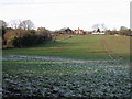
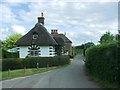
A less verdant view of Frogham
A view of Frogham see Image taken one year earlier
Image: © Nick Smith
Taken: 11 Jan 2009
0.01 miles

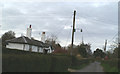

8
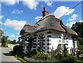
Gate Cottage, Frogham, Nonington
A Grade II listed building, 18th century, formerly a gate lodge to Fredville Park.
Image: © pam fray
Taken: 23 Aug 2023
0.10 miles
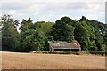
10
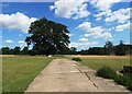
Fredville Park, Nonington
The southern end of the track.
Image: © pam fray
Taken: 23 Aug 2023
0.11 miles