IMAGES TAKEN NEAR TO
Canterbury Road, DOVER, CT15 7HP
Introduction
This page details the photographs taken nearby to Canterbury Road, CT15 7HP by members of the Geograph project.
The Geograph project started in 2005 with the aim of publishing, organising and preserving representative images for every square kilometre of Great Britain, Ireland and the Isle of Man.

There are currently over 7.5m images from over14,400 individuals and you can help contribute to the project by visiting https://www.geograph.org.uk
Image Map
Images are licensed for reuse under creativecommons.org/licenses/by-sa/2.0
Notes
- Clicking on the map will re-center to the selected point.
- The higher the marker number, the further away the image location is from the centre of the postcode.
Image Listing (11 Images Found)
Images are licensed for reuse under creativecommons.org/licenses/by-sa/2.0
Image
Details
Distance
1
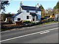
Foxhill Cottage, Canterbury Road (A260)
The exterior of Image appeared immaculate, when I last photographed it, but it seems that there was a problem afterwards with cracks appearing.
Image: © John Baker
Taken: 17 Dec 2016
0.04 miles
2
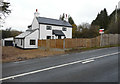
Foxhill Cottage, Canterbury Road (A260)
It is up for sale through the estate agents Bairstoweves at offers in the region of £575,000. The sales particulars (ref 4465681) describe the property as having a large driveway for multiple vehicles as well as a detached garage, [which is] fully powered and has its own water supply. The substantial garden surrounding the property is mostly laid to lawn with a slate patio area. Internally, the property has been completely renovated with new flooring, modern fitted kitchen with utility room and downstairs cloakroom, brand new family bathroom and en suite shower room to the master bedroom. There are four bedrooms in total with a study that could double as a fifth bedroom. The main living area is a generous 'L' shaped room with bi folding doors overlooking the garden http://www.bairstoweves.co.uk
This image shows Image in December 2016.
Image: © John Baker
Taken: 15 Dec 2017
0.04 miles
3
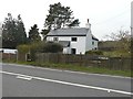
Foxhill Cottage, Canterbury Road (A260)
The house has been undergoing refurbishment and the exterior has been repainted. The van, on the left, belongs to the contractors, who have been carrying out the work.
Image: © John Baker
Taken: 11 Apr 2016
0.04 miles
4
Swingfield Minnis, Canterbury Road (A260)
Image: © Helmut Zozmann
Taken: 22 Jul 2011
0.07 miles
5
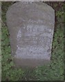
Old Milestone by the A260, Canterbury Road, Swingfield
Carved stone post by the A260, in parish of Swingfield (Shepway District), Canterbury Road, Selsted, 200m North of junction with Mansell Lane, back of verge, against hedge, on East side of road. Barham road stone, erected by the Folkestone & Barham turnpike trust in the 19th century.
Inscription reads:-
CANTERBURY
10 MILES
FOLKESTONE
5½ MILES
Carved benchmark recorded.
Kent HER.
HER Number: TR 24 SW 52 https://www.heritagegateway.org.uk/Gateway/Results_Single.aspx?uid=MKE77399&resourceID=1005
Milestone Society National ID: KE_CYFO10
Image: © C Woodward
Taken: 21 Apr 2008
0.10 miles
6
Swingfield Minnis, Canterbury Road (A260)
Image: © Helmut Zozmann
Taken: 22 Jul 2011
0.11 miles
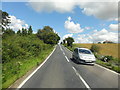
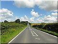
7
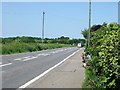
A260 Canterbury Road
Towards Canterbury.
Image: © Robin Webster
Taken: 29 Jun 2019
0.13 miles
8
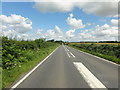
Swingfield Minnis, Canterbury Road (A260)
Image: © Helmut Zozmann
Taken: 22 Jul 2011
0.18 miles
9
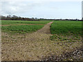
Footpath across a field
It runs from Reece Lane to Canterbury Road (A260).
Image: © John Baker
Taken: 8 Mar 2019
0.20 miles
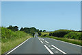
10
Looking NNE along the A260 Canterbury Road
Image: © Nick Smith
Taken: 9 Jun 2008
0.21 miles