IMAGES TAKEN NEAR TO
Swingfield, DOVER, CT15 7HF
Introduction
This page details the photographs taken nearby to CT15 7HF by members of the Geograph project.
The Geograph project started in 2005 with the aim of publishing, organising and preserving representative images for every square kilometre of Great Britain, Ireland and the Isle of Man.

There are currently over 7.5m images from over14,400 individuals and you can help contribute to the project by visiting https://www.geograph.org.uk
Image Map
Images are licensed for reuse under creativecommons.org/licenses/by-sa/2.0
Notes
- Clicking on the map will re-center to the selected point.
- The higher the marker number, the further away the image location is from the centre of the postcode.
Image Listing (19 Images Found)
Images are licensed for reuse under creativecommons.org/licenses/by-sa/2.0
Image
Details
Distance
1
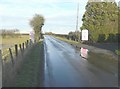
Entrance to The Old Kent Barn
A venue for weddings http://www.theoldkentbarn.co.uk/weddings/
Image: © John Baker
Taken: 20 Feb 2014
0.03 miles
2
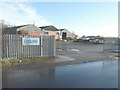
CoPlant depot
Suppliers and hirers of construction and agricultural machinery http://www.coplant.co.uk/
Image: © John Baker
Taken: 20 Feb 2014
0.06 miles
3
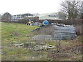
Agwood Ltd
Agwood commenced trading in 1978 and has grown and evolved to the present day. The dealership covers Kent and East Sussex for the Massey Ferguson range of tractors, harvesting and groundcare equipment. It is the authorised dealer for the JCB Landpower range of Fastrac, Loadalls, wheeled loaders and Workmax machines covering most of Kent. In 2017 Agwood Ltd was appointed as the main dealer for Sky Agriculture cultivation and seed drilling machinery in Kent; Sky Agriculture seed drills provide high capacity drilling solutions for all soil conditions and cultivation systems. It is also the authorised dealer for Suzuki ATV in Kent https://www.agwood.co.uk/index.php/about-us
Here, a new building is under construction beyond the main building.
Image: © John Baker
Taken: 5 Jan 2020
0.08 miles
4
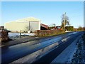
Agwood Ltd - Agricultural Machinery Dealers
These dealers stock Massey Ferguson tractors, one of which can partly be seen behind the hedge.
Image: © John Baker
Taken: 20 Dec 2009
0.08 miles
5
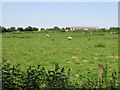
View across the field towards Smezzel
Written as Smezzel on the OS maps, the Magic (Multi Agency Geographic Information) map shows this as Smersole http://magic.defra.gov.uk/website/magic/opener.htm?startTopic=magicall&chosenLayers=moncIndex&xygridref=621877,143566&startScale=5000
Image: © Nick Smith
Taken: 9 Jun 2008
0.11 miles
6
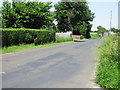
Looking NE along the road to Lydden towards Smezzel
Written as Smezzel on OS maps but also as Smersole on others http://magic.defra.gov.uk/website/magic/opener.htm?startTopic=magicall&chosenLayers=moncIndex&xygridref=621877,143566&startScale=5000
Image: © Nick Smith
Taken: 9 Jun 2008
0.14 miles
7
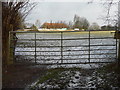
Looking northeast from an unnamed lane
Towards the wedding venue known as the Old Kent Barn in Image
Image: © John Baker
Taken: 3 Feb 2015
0.15 miles
8
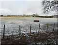
The end of Mansell Lane
Mansell Lane leads from the A260 Canterbury past several cottages and Little Smezzel Farm, before ending at Little Garth Cottage, then a bridleway carries on along a track towards Swanton Lane.
Image: © David Anstiss
Taken: 12 Dec 2010
0.17 miles
9
Looking northeast from an unnamed lane
Towards the wedding venue known as the Old Kent Barn in Image
Image: © John Baker
Taken: 3 Feb 2015
0.18 miles
10
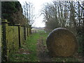
Bridleway to Canterbury Road
This track leads from Swanton Lane, and becomes Mansell Lane at Little Garth (cottage in the background), before heading to the A260.
Image: © David Anstiss
Taken: 12 Dec 2010
0.19 miles