IMAGES TAKEN NEAR TO
St. Marys Rise, DOVER, CT15 7FH
Introduction
This page details the photographs taken nearby to St. Marys Rise, CT15 7FH by members of the Geograph project.
The Geograph project started in 2005 with the aim of publishing, organising and preserving representative images for every square kilometre of Great Britain, Ireland and the Isle of Man.

There are currently over 7.5m images from over14,400 individuals and you can help contribute to the project by visiting https://www.geograph.org.uk
Image Map
Images are licensed for reuse under creativecommons.org/licenses/by-sa/2.0
Notes
- Clicking on the map will re-center to the selected point.
- The higher the marker number, the further away the image location is from the centre of the postcode.
Image Listing (103 Images Found)
Images are licensed for reuse under creativecommons.org/licenses/by-sa/2.0
Image
Details
Distance
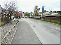
1
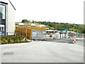
Lydden Hills
Lydden Hills is a housing estate off Canterbury Road, which is under construction.
Image: © John Baker
Taken: 25 Jun 2022
0.01 miles
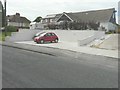
2
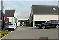
Lydden Hills
Lydden Hills is a housing estate off Canterbury Road, which is under construction.
A similar view of Image was taken in June 2022
Image: © John Baker
Taken: 1 Sep 2023
0.02 miles
3
Lydden Hills
Lydden Hills is a housing estate off Canterbury Road, which is under construction.
A similar view of Image taken in November 2021.
Image: © John Baker
Taken: 25 Jun 2022
0.02 miles
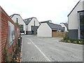
4
Lydden Hills
Lydden Hills is a housing estate off Canterbury Road, which is under construction.
Image: © John Baker
Taken: 13 Nov 2021
0.02 miles
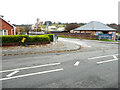
5
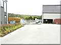
Road to Lydden Hills
Lydden Hills is a housing estate off Canterbury Road, which is under construction.
Image: © John Baker
Taken: 13 Nov 2021
0.04 miles
6
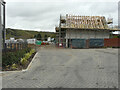
Lydden Hills
Lydden Hills is a housing estate off Canterbury Road, which is under construction.
Image: © John Baker
Taken: 13 Nov 2021
0.04 miles
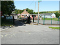
7
Entrance to Lydden Hills
Lydden Hills is a housing estate off Canterbury Road, which is under construction.
Image: © John Baker
Taken: 13 Nov 2021
0.06 miles
8
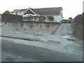
Excavation at 120 Canterbury Road
As I passed earlier on my way to Dover, a JCB was excavating the garden in front of the house to create this area, which I photographed on my return journey.
Image: © John Baker
Taken: 7 Feb 2014
0.08 miles
9
Car parking facility at 120 Canterbury Road
This area appeared as an Image on 7 February 2014. There is still work to be completed on the slope leading up to the house.
Image: © John Baker
Taken: 8 Jun 2014
0.08 miles
10
Lydden County Primary School, Stonehall Road
Dover District Council has raised no objection under application number DOV/21/00956 for the “demolition of existing school hall and replacement with new school hall linked to existing building, formation of new vehicular access and staff car park”
Image: © John Baker
Taken: 17 Jul 2021
0.09 miles