IMAGES TAKEN NEAR TO
Belsey Lane, DOVER, CT15 7FG
Introduction
This page details the photographs taken nearby to Belsey Lane, CT15 7FG by members of the Geograph project.
The Geograph project started in 2005 with the aim of publishing, organising and preserving representative images for every square kilometre of Great Britain, Ireland and the Isle of Man.

There are currently over 7.5m images from over14,400 individuals and you can help contribute to the project by visiting https://www.geograph.org.uk
Image Map (Loading...)


Getting Data...Please wait
Leaflet Map data © OpenStreetMap
Images are licensed for reuse under creativecommons.org/licenses/by-sa/2.0
Notes
- Clicking on the map will re-center to the selected point.
- The higher the marker number, the further away the image location is from the centre of the postcode.
Image Listing (9 Images Found)
Images are licensed for reuse under creativecommons.org/licenses/by-sa/2.0
Image
Details
Distance
2
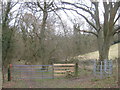
Gate, stile and kissing gate near Brown's Wood
A footpath heads into Brown's Wood via the stile. The kissing gate is on another footpath heading right towards Belsey Lane, Ewell Minnis, which also heads left around the wood towards Warren Lane.
Image: © David Anstiss
Taken: 6 Mar 2011
0.14 miles
3
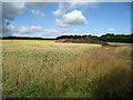
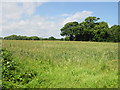
Wheat Field and Manure Heap
Adjacent Belsey Lane.
Image: © Oast House Archive
Taken: 17 Jul 2010
0.15 miles
4
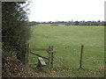
Stile near Brown's Wood
A footpath leads from Warren Lane, past the wood and onwards to Belsey Lane in Ewell Minnis, near Minnis Farm.
Image: © David Anstiss
Taken: 6 Mar 2011
0.18 miles
5
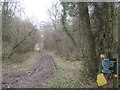
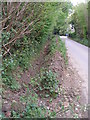
Permissive path in Brown's Wood
This path leads through the wood (that is also used by the military for training purposes) towards a path towards Lydden.
Image: © David Anstiss
Taken: 6 Mar 2011
0.19 miles
7
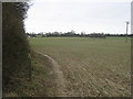
Footpath junction near Brown's Wood
A footpath from Warren Lane, leads past Brown's Wood towards Belsey Lane in Ewell Minnis. Another footpath cuts across the field (towards the pole) and to Belsey Lane (on a path towards Green Lane near Chalksole Green).
Image: © David Anstiss
Taken: 6 Mar 2011
0.24 miles
9
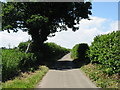
Footpath crossing Ferne Lane near Chalksole
Image: © Nick Smith
Taken: 28 Jun 2008
0.25 miles