IMAGES TAKEN NEAR TO
Common Hill, DOVER, CT15 7DX
Introduction
This page details the photographs taken nearby to Common Hill, CT15 7DX by members of the Geograph project.
The Geograph project started in 2005 with the aim of publishing, organising and preserving representative images for every square kilometre of Great Britain, Ireland and the Isle of Man.

There are currently over 7.5m images from over14,400 individuals and you can help contribute to the project by visiting https://www.geograph.org.uk
Image Map
Images are licensed for reuse under creativecommons.org/licenses/by-sa/2.0
Notes
- Clicking on the map will re-center to the selected point.
- The higher the marker number, the further away the image location is from the centre of the postcode.
Image Listing (5 Images Found)
Images are licensed for reuse under creativecommons.org/licenses/by-sa/2.0
Image
Details
Distance
1
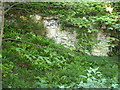
Exposed chalk cliff
Set at the top of a 1 in 5 road (20% in metric). The ferns below were very lush.
Image: © Carol Rose
Taken: 31 May 2007
0.10 miles
2
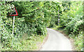
Warren Lane - Steep Hill 20%
Warren Lane, Alkham. 20% steep hill up sign.
Image: © Adam Morse
Taken: 30 Jul 2009
0.12 miles
3
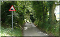
Warren Lane - Steep Hill 20%
Warren Lane, Alkham. 20% steep hill down sign.
Image: © Adam Morse
Taken: 30 Jul 2009
0.13 miles
4
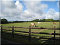
Horses at Chalksole Green
At Whitehill Farm.
Image: © Oast House Archive
Taken: 17 Jul 2010
0.16 miles
5
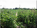
Looking S along footpath to Green Lane
The path links into the bridleway along Green Lane from Ewell Minnis http://www.geograph.org.uk/photo/871155
Image: © Nick Smith
Taken: 28 Jun 2008
0.22 miles