IMAGES TAKEN NEAR TO
Meggett Lane, DOVER, CT15 7DG
Introduction
This page details the photographs taken nearby to Meggett Lane, CT15 7DG by members of the Geograph project.
The Geograph project started in 2005 with the aim of publishing, organising and preserving representative images for every square kilometre of Great Britain, Ireland and the Isle of Man.

There are currently over 7.5m images from over14,400 individuals and you can help contribute to the project by visiting https://www.geograph.org.uk
Image Map
Images are licensed for reuse under creativecommons.org/licenses/by-sa/2.0
Notes
- Clicking on the map will re-center to the selected point.
- The higher the marker number, the further away the image location is from the centre of the postcode.
Image Listing (4 Images Found)
Images are licensed for reuse under creativecommons.org/licenses/by-sa/2.0
Image
Details
Distance
1
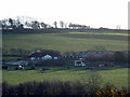
Uplands Farm
Looking SE from the road in the NW corner of the square.
Image: © Chris Shaw
Taken: 31 Dec 2005
0.12 miles
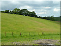
3
View through field entrance near Alkham
Image: © Robin Webster
Taken: 12 Jun 2014
0.21 miles
4
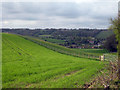
View to Alkham Village
Across fields adjacent Hogbrook Hill Lane.
Image: © Oast House Archive
Taken: 7 May 2010
0.23 miles