IMAGES TAKEN NEAR TO
Crooks Court Lane, DOVER, CT15 7BN
Introduction
This page details the photographs taken nearby to Crooks Court Lane, CT15 7BN by members of the Geograph project.
The Geograph project started in 2005 with the aim of publishing, organising and preserving representative images for every square kilometre of Great Britain, Ireland and the Isle of Man.

There are currently over 7.5m images from over14,400 individuals and you can help contribute to the project by visiting https://www.geograph.org.uk
Image Map
Images are licensed for reuse under creativecommons.org/licenses/by-sa/2.0
Notes
- Clicking on the map will re-center to the selected point.
- The higher the marker number, the further away the image location is from the centre of the postcode.
Image Listing (33 Images Found)
Images are licensed for reuse under creativecommons.org/licenses/by-sa/2.0
Image
Details
Distance
1
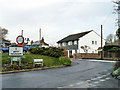
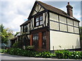
Entering West Hougham
At the junction of Gravel Lane with Satmar Lane.
Image: © Robin Webster
Taken: 16 Jan 2013
0.05 miles
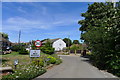
7
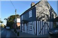
The former Chequers Inn, 18 The Street
The demise of another country pub.
Image: © Nick Smith
Taken: 20 Jul 2008
0.11 miles
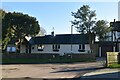
9
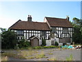
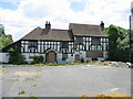
Chequers Inn, West Hougham
Disused pub on The Street.
Image: © Oast House Archive
Taken: 17 Jul 2010
0.11 miles
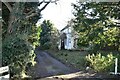
10
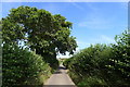
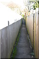
Satmar Lane leading to West Hougham
How does the name 'Satmar' originate?
Image: © Tim Heaton
Taken: 8 Aug 2019
0.12 miles