IMAGES TAKEN NEAR TO
West Hougham, DOVER, CT15 7AY
Introduction
This page details the photographs taken nearby to CT15 7AY by members of the Geograph project.
The Geograph project started in 2005 with the aim of publishing, organising and preserving representative images for every square kilometre of Great Britain, Ireland and the Isle of Man.

There are currently over 7.5m images from over14,400 individuals and you can help contribute to the project by visiting https://www.geograph.org.uk
Image Map (Loading...)


Getting Data...Please wait
Leaflet Map data © OpenStreetMap
Images are licensed for reuse under creativecommons.org/licenses/by-sa/2.0
Notes
- Clicking on the map will re-center to the selected point.
- The higher the marker number, the further away the image location is from the centre of the postcode.
Image Listing (39 Images Found)
Images are licensed for reuse under creativecommons.org/licenses/by-sa/2.0
Image
Details
Distance
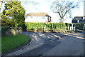
2
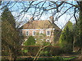
Coxhill House, West Hougham
Grade II Listed house on the junction of The Street (in front) and Meggett Lane.
See http://www.britishlistedbuildings.co.uk/en-178607-coxhill-house-hougham-without for more details about the building.
Image: © David Anstiss
Taken: 27 Feb 2011
0.04 miles
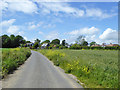
7
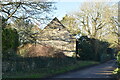
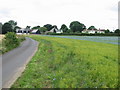
The Street leaving West Hougham
After leaving the village the road is called Lowslip Hill
Image: © Tim Heaton
Taken: 8 Aug 2019
0.05 miles
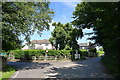
9
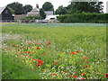
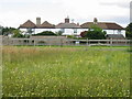
Wild flowers in the flax field, West Hougham
Image: © Nick Smith
Taken: 20 Jul 2008
0.08 miles