IMAGES TAKEN NEAR TO
Elms Hill, DOVER, CT15 7AS
Introduction
This page details the photographs taken nearby to Elms Hill, CT15 7AS by members of the Geograph project.
The Geograph project started in 2005 with the aim of publishing, organising and preserving representative images for every square kilometre of Great Britain, Ireland and the Isle of Man.

There are currently over 7.5m images from over14,400 individuals and you can help contribute to the project by visiting https://www.geograph.org.uk
Image Map
Images are licensed for reuse under creativecommons.org/licenses/by-sa/2.0
Notes
- Clicking on the map will re-center to the selected point.
- The higher the marker number, the further away the image location is from the centre of the postcode.
Image Listing (26 Images Found)
Images are licensed for reuse under creativecommons.org/licenses/by-sa/2.0
Image
Details
Distance
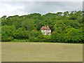
1
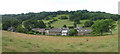
Looking N to Soval on Elms Road
The house is the Old Vicarage
Image: © Nick Smith
Taken: 20 Jul 2008
0.02 miles
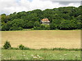
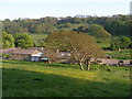
2
The Old Vicarage, Elms Hill, Hougham
A large house with a good view to the south.
Image: © Robin Webster
Taken: 12 Jun 2014
0.04 miles
3
The Old Vicarage under repair, Elms Hill
Image: © Nick Smith
Taken: 20 Jul 2008
0.04 miles
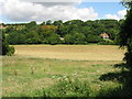
8
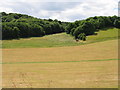
Looking S across farmland
Looking back towards the point where http://www.geograph.org.uk/photo/920789 was taken on the opposite side of the valley.
Image: © Nick Smith
Taken: 20 Jul 2008
0.10 miles
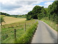
10
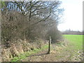
Footpath into Long Wood
A path leads from West Hougham (via a bridleway) then a footpath heads into the wood to lead towards Dover.
Image: © David Anstiss
Taken: 27 Feb 2011
0.12 miles