IMAGES TAKEN NEAR TO
Knoll Court, High Street, DOVER, CT15 6FT
Introduction
This page details the photographs taken nearby to Knoll Court, High Street, CT15 6FT by members of the Geograph project.
The Geograph project started in 2005 with the aim of publishing, organising and preserving representative images for every square kilometre of Great Britain, Ireland and the Isle of Man.

There are currently over 7.5m images from over14,400 individuals and you can help contribute to the project by visiting https://www.geograph.org.uk
Image Map
Images are licensed for reuse under creativecommons.org/licenses/by-sa/2.0
Notes
- Clicking on the map will re-center to the selected point.
- The higher the marker number, the further away the image location is from the centre of the postcode.
Image Listing (169 Images Found)
Images are licensed for reuse under creativecommons.org/licenses/by-sa/2.0
Image
Details
Distance
1
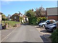
Chapel Lane, St. Margaret's at Cliffe
Image: © Chris Whippet
Taken: 23 Apr 2017
0.01 miles

4
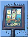
St Margaret's-at-Cliffe
Colourful village sign showing the saint, dragon, South Foreland lighthouse, church and the white cliffs.
http://stmargaretspc.co.uk/
Image: © Colin Smith
Taken: 21 Apr 2011
0.02 miles
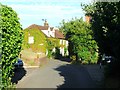
5
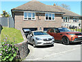
Cherry Bank, Chapel Lane
Planning permission has been granted by Dover District Council under application number DOV/20/00706 for the “erection of a single storey rear extension and change garage door for patio doors to front elevation”.
This view of Image was taken after the patio doors had been installed.
Image: © John Baker
Taken: 30 Jul 2020
0.03 miles
6
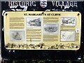
St Margaret's at Cliffe features [1]
An information board about the village.
St Margaret’s at Cliffe is a coastal village some 3 miles northeast of Dover. The village is the place in Britain that is nearest to the coast of France, 18 miles distant. The area has been settled since Anglo-Saxon times, and the village became a high class resort in the nineteenth century. The area has always been at the front line of cross Channel conflicts.
Image: © Michael Dibb
Taken: 12 Sep 2021
0.03 miles
7
Cherry Bank, Chapel Lane
This view of Image was taken before the left hand garage door was removed and the patio doors installed.
Image: © John Baker
Taken: 13 Jun 2021
0.03 miles
8
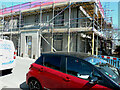
Flat 1, Curfew House, 14, Kingsdown Road
Planning permission has been granted by Dover District Council under application number DOV/19/00568 for the “erection of single and two storey rear extensions and conversion to form 2 flats (existing first floor to be demolished)”.
This was Image without the scaffolding.
Image: © John Baker
Taken: 13 Jun 2021
0.03 miles
10
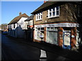
The High Street, St Margaret's at Cliffe
The Accountants, the Post Office and The Smugglers pub.
http://stmargaretsphotodiary.blogspot.com/2007_01_07_archive.html
Image: © Nick Smith
Taken: 12 Jan 2008
0.03 miles