IMAGES TAKEN NEAR TO
Foreland Road, DOVER, CT15 6EB
Introduction
This page details the photographs taken nearby to Foreland Road, CT15 6EB by members of the Geograph project.
The Geograph project started in 2005 with the aim of publishing, organising and preserving representative images for every square kilometre of Great Britain, Ireland and the Isle of Man.

There are currently over 7.5m images from over14,400 individuals and you can help contribute to the project by visiting https://www.geograph.org.uk
Image Map
Images are licensed for reuse under creativecommons.org/licenses/by-sa/2.0
Notes
- Clicking on the map will re-center to the selected point.
- The higher the marker number, the further away the image location is from the centre of the postcode.
Image Listing (105 Images Found)
Images are licensed for reuse under creativecommons.org/licenses/by-sa/2.0
Image
Details
Distance
1
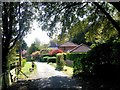
Foreland Road, St. Margaret's at Cliffe
Image: © Chris Whippet
Taken: 23 Apr 2017
0.05 miles
2
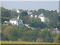
St Margaret's Bay
Sea views from these upmarket houses above a dry valley in St Margaret's Bay. This is in a cuesta landscape of parallel valleys in a downland environment.
Image: © Colin Smith
Taken: 21 Apr 2011
0.05 miles
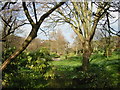
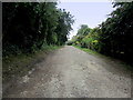
5
![A walk to the South Foreland Lighthouse and return [27]](https://s3.geograph.org.uk/geophotos/07/10/40/7104055_8177a76d_120x120.jpg)
A walk to the South Foreland Lighthouse and return [27]
A view along the track known as Beach Road. This track is one of two parallel tracks which run along the cliffs from St Margaret's at Cliffe to the South Foreland Lighthouse.
Starting from the church at St Margaret’s at Cliffe, the walk passes through housing then over the flank of Bay Hill. Continuing through an area of scrub laid out with roads (presumably for a housing development that was never built) the lighthouse is reached. The return route is along the cliff tops to the lower part of St Margaret’s at Cliffe before a steep ascent of Bay Hill back to the church.
Image: © Michael Dibb
Taken: 13 Sep 2021
0.11 miles
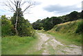
6
Saxon Shore Way leaving St. Margaret's at Cliffe
A track takes the long distance footpath south west out of the community of St. Margaret's at Cliffe.
Image: © Chris Heaton
Taken: 18 Oct 2013
0.12 miles
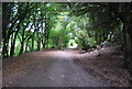
7
![A walk to the South Foreland Lighthouse and return [28]](https://s3.geograph.org.uk/geophotos/07/10/40/7104075_9b334fe9_120x120.jpg)
A walk to the South Foreland Lighthouse and return [28]
From the junction of the tracks this path leads to The Front.
Starting from the church at St Margaret’s at Cliffe, the walk passes through housing then over the flank of Bay Hill. Continuing through an area of scrub laid out with roads (presumably for a housing development that was never built) the lighthouse is reached. The return route is along the cliff tops to the lower part of St Margaret’s at Cliffe before a steep ascent of Bay Hill back to the church.
Image: © Michael Dibb
Taken: 13 Sep 2021
0.12 miles
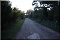
10
![A walk to the South Foreland Lighthouse and return [29]](https://s0.geograph.org.uk/geophotos/07/10/40/7104076_afba9de5_120x120.jpg)
A walk to the South Foreland Lighthouse and return [29]
A 'No Motorized Vehicles' sign at the junction of the tracks.
Starting from the church at St Margaret’s at Cliffe, the walk passes through housing then over the flank of Bay Hill. Continuing through an area of scrub laid out with roads (presumably for a housing development that was never built) the lighthouse is reached. The return route is along the cliff tops to the lower part of St Margaret’s at Cliffe before a steep ascent of Bay Hill back to the church.
Image: © Michael Dibb
Taken: 13 Sep 2021
0.13 miles