IMAGES TAKEN NEAR TO
Beach Road, DOVER, CT15 6DZ
Introduction
This page details the photographs taken nearby to Beach Road, CT15 6DZ by members of the Geograph project.
The Geograph project started in 2005 with the aim of publishing, organising and preserving representative images for every square kilometre of Great Britain, Ireland and the Isle of Man.

There are currently over 7.5m images from over14,400 individuals and you can help contribute to the project by visiting https://www.geograph.org.uk
Image Map
Images are licensed for reuse under creativecommons.org/licenses/by-sa/2.0
Notes
- Clicking on the map will re-center to the selected point.
- The higher the marker number, the further away the image location is from the centre of the postcode.
Image Listing (152 Images Found)
Images are licensed for reuse under creativecommons.org/licenses/by-sa/2.0
Image
Details
Distance
3
![A walk from St Margaret?s at Cliffe to Kingsdown and return [64]](https://s1.geograph.org.uk/geophotos/07/08/68/7086857_cc6d2c45_120x120.jpg)
A walk from St Margaret?s at Cliffe to Kingsdown and return [64]
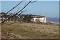
The view from the junction of Granville Road and Hotel Road. Ness Point is seen in the distance.
Starting from the Dover Patrol Monument, the walk follows the long distance Saxon Shore Way along the top of the cliffs before descending to the bay at Kingsdown. Heading inland there is an ascent of Wood Hill before various rights of way run across fields to the wonderfully named Otty Bottom, then on to Free Down and a return to the starting point. A little more than 5 miles.
Image: © Michael Dibb
Taken: 12 Sep 2021
0.04 miles
4
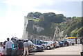
Ness Point at St Margaret's at Cliffe
A cross-channel ferry heads for Dover.
Image: © Gareth James
Taken: 31 Mar 2019
0.04 miles
5
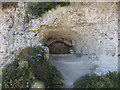
Tunnel entrance, St Margaret's Bay
Blocked entrance to a World War II tunnel system in the cliffs. It linked to a machine gun post protecting the beach Image See http://www.subterraneanhistory.co.uk/2006/04/st-margarets-bay-cliff-complex.html for photos of the tunnels.
Image: © Hugh Venables
Taken: 13 Aug 2011
0.04 miles
6
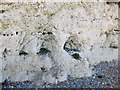
Corrasion weathering
A weaker upper layer of the chalk cliffs is being eroded at St Margaret's at Cliffe by the action of waves and pebbles of more resistant rock grinding against the chalk.
Image: © Hugh Venables
Taken: 13 Aug 2011
0.04 miles
7
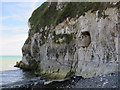
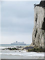
Ness Point, St Margaret's Bay
The end of a tunnel protrudes out of the chalk cliff. This was a machine gun post to protect the beach from a potential landing in the World War II. The tunnel is brick lined with a tin roof, see http://www.subterraneanhistory.co.uk/2006/04/st-margarets-bay-cliff-complex.html
Image: © Hugh Venables
Taken: 13 Aug 2011
0.04 miles
8
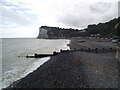
Looking towards Ness Point
At St Margaret's Bay
Image: © Tim Glover
Taken: 10 Sep 2021
0.05 miles
9

Ornamental Gates
Wavy patterned gates and shadows at the entrance to The Pines Garden, an "eco-garden", in St Margaret's Bay.
Image: © Colin Smith
Taken: 21 Apr 2011
0.05 miles
10
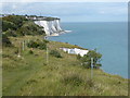
The white cliffs
The photograph is taken from where the path to Dover reaches the cliff top again near Ness Point. The Dover Patrol Memorial is on the horizon - see http://www.geograph.org.uk/photo/2548972
Image: © Marathon
Taken: 24 Aug 2017
0.05 miles