IMAGES TAKEN NEAR TO
The Droveway, DOVER, CT15 6DF
Introduction
This page details the photographs taken nearby to The Droveway, CT15 6DF by members of the Geograph project.
The Geograph project started in 2005 with the aim of publishing, organising and preserving representative images for every square kilometre of Great Britain, Ireland and the Isle of Man.

There are currently over 7.5m images from over14,400 individuals and you can help contribute to the project by visiting https://www.geograph.org.uk
Image Map
Images are licensed for reuse under creativecommons.org/licenses/by-sa/2.0
Notes
- Clicking on the map will re-center to the selected point.
- The higher the marker number, the further away the image location is from the centre of the postcode.
Image Listing (54 Images Found)
Images are licensed for reuse under creativecommons.org/licenses/by-sa/2.0
Image
Details
Distance
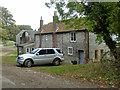
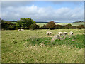
2
Bockhill Farm
The folk loitering by the corner of the barn are hoping to see a Yellow-browed Warbler tipped to be in the small wood off to the right.
Image: © Robin Webster
Taken: 14 Oct 2017
0.03 miles
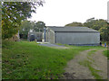
3
Bockhill Farm from Bockell Hill
A section of Bockell Hill has been fenced and is being grazed by ponies to preserve the natural habitat. I was standing within this area.
Image: © John Baker
Taken: 21 Dec 2012
0.03 miles
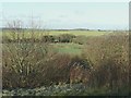
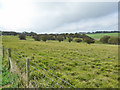
4
Northwest view from Bockell Hill
A section of Bockell Hill has been fenced and is being grazed by ponies to preserve the natural habitat. I was standing within this area. The line of hedging, in the centre view, marks the route of The Droveway which terminates at Bockhill Farm.
Image: © John Baker
Taken: 21 Dec 2012
0.11 miles
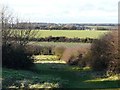
5
St.Margaret's Free Down
Access land, but there is no way in directly from the permissive path National Trust path towards Bockhill Farm which is the viewpoint.
Image: © Robin Webster
Taken: 14 Oct 2017
0.13 miles
6
St.Margaret's Free Down
Access land, but there is no way in directly from the permissive path National Trust path towards Bockhill Farm which is the viewpoint.
Image: © Robin Webster
Taken: 14 Oct 2017
0.19 miles
7
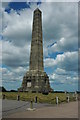
Memorial to the Dover Patrol
This prominent obelisk stands on the cliffs above St Margaret's at Cliffe and is a lasting memorial to those of the Dover Patrol lost in two World Wars.
Image: © Philip Halling
Taken: 18 Jul 2009
0.19 miles
8
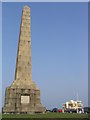
The Dover Patrol Memorial
This monument, designed by Sir Aston Webb R.A., is one of three constructed in the memory of almost 2000 men the Dover Patrol lost during the Great War. The other monuments are across the Channel at Cap Gris Nez, France and by Brooklyn Bridge in New York.
Image: © Robin Drayton
Taken: 16 Sep 2006
0.20 miles
9
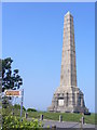
Dover Patrol Obelisk
Landmark memorial on the clifftop at St Margaret's Bay. It commemorates seamen who patrolled the Straits of Dover during WW1 and WW2.
Image: © Colin Smith
Taken: 21 Apr 2011
0.20 miles
10
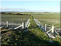
Footpath heading towards Bockhill Farm
Of interest, to me, was the newly erected fence.
Image: © John Baker
Taken: 21 Dec 2012
0.20 miles