IMAGES TAKEN NEAR TO
High Street, DOVER, CT15 6AT
Introduction
This page details the photographs taken nearby to High Street, CT15 6AT by members of the Geograph project.
The Geograph project started in 2005 with the aim of publishing, organising and preserving representative images for every square kilometre of Great Britain, Ireland and the Isle of Man.

There are currently over 7.5m images from over14,400 individuals and you can help contribute to the project by visiting https://www.geograph.org.uk
Image Map
Images are licensed for reuse under creativecommons.org/licenses/by-sa/2.0
Notes
- Clicking on the map will re-center to the selected point.
- The higher the marker number, the further away the image location is from the centre of the postcode.
Image Listing (166 Images Found)
Images are licensed for reuse under creativecommons.org/licenses/by-sa/2.0
Image
Details
Distance
2
St Margaret's at Cliffe buildings [2]
This large building was originally a series of outbuildings to Cliffe House Image Constructed at various dates from the 18th century to the end of the 19th century. Constructed of brick, partly weatherboarded, partly rendered, partly painted, under a mix of slate and tile roofs. Until recently, a hotel, now holiday accommodation. Listed, for group value, grade II, with details at: https://historicengland.org.uk/listing/the-list/list-entry/1363365
St Margaret’s at Cliffe is a coastal village some 3 miles northeast of Dover. The village is the place in Britain that is nearest to the coast of France, 18 miles distant. The area has been settled since Anglo-Saxon times, and the village became a high class resort in the nineteenth century. The area has always been at the front line of cross Channel conflicts.
Image: © Michael Dibb
Taken: 12 Sep 2021
0.01 miles
3
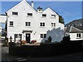
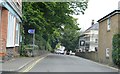
St. Margaret's at Cliffe High Street
This High Street leads from Station Road towards Sea Street (leading towards the bay). On the left is Well Lane. Image on the right is seen.
Image: © David Anstiss
Taken: 24 Apr 2011
0.02 miles
4
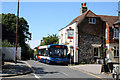
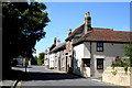
St. Margaret's at Cliffe, Kent: Bus outside the 'Hope Inn'
This bus is operating on the long Route 15, which runs Canterbury-Lydden-Dover-Deal. Although the bus is in Stagecoach livery, it is branded as 'The Diamond'.
Image: © Dr Neil Clifton
Taken: 22 Jul 2010
0.02 miles
5
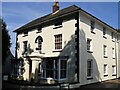
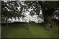
St Margaret's at Cliffe buildings [1]
Cliffe House, High Street, was built circa 1830. Constructed of painted brick with rendered quoins and a hipped slate roof. Now flats. Listed, grade II, with details at: https://historicengland.org.uk/listing/the-list/list-entry/1101769
St Margaret’s at Cliffe is a coastal village some 3 miles northeast of Dover. The village is the place in Britain that is nearest to the coast of France, 18 miles distant. The area has been settled since Anglo-Saxon times, and the village became a high class resort in the nineteenth century. The area has always been at the front line of cross Channel conflicts.
Image: © Michael Dibb
Taken: 12 Sep 2021
0.02 miles
7
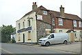
St. Margaret's at Cliffe, Kent: Sea Street
Looking northwest. The 'Hope Inn' is at the far end of the block, on the right.
Image: © Dr Neil Clifton
Taken: 22 Jul 2010
0.02 miles
9
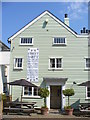
Let's Have a Party
Attractive weatherboarded White Cliffs Hotel in St Margaret's at Cliffe with a banner advertising next week's street party. Friday 29th April and a Public Holiday to commemorate the Royal Wedding of Prince William and Catherine Middleton.
http://stmargaretspc.co.uk/
Image: © Colin Smith
Taken: 21 Apr 2011
0.02 miles
10
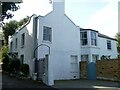
St Margaret's at Cliffe buildings [6]
Cliffe Cottage, in Cripps' Lane, is an early 19th century house. Constructed of rendered brick under a slate roof. Listed, for group value, grade II, with details at: https://historicengland.org.uk/listing/the-list/list-entry/1347921
St Margaret’s at Cliffe is a coastal village some 3 miles northeast of Dover. The village is the place in Britain that is nearest to the coast of France, 18 miles distant. The area has been settled since Anglo-Saxon times, and the village became a high class resort in the nineteenth century. The area has always been at the front line of cross Channel conflicts.
Image: © Michael Dibb
Taken: 12 Sep 2021
0.02 miles