IMAGES TAKEN NEAR TO
Langdon Battery, DOVER, CT15 5NA
Introduction
This page details the photographs taken nearby to Langdon Battery, CT15 5NA by members of the Geograph project.
The Geograph project started in 2005 with the aim of publishing, organising and preserving representative images for every square kilometre of Great Britain, Ireland and the Isle of Man.

There are currently over 7.5m images from over14,400 individuals and you can help contribute to the project by visiting https://www.geograph.org.uk
Image Map (Loading...)


Getting Data...Please wait
Leaflet Map data © OpenStreetMap
Images are licensed for reuse under creativecommons.org/licenses/by-sa/2.0
Notes
- Clicking on the map will re-center to the selected point.
- The higher the marker number, the further away the image location is from the centre of the postcode.
Image Listing (104 Images Found)
Images are licensed for reuse under creativecommons.org/licenses/by-sa/2.0
Image
Details
Distance
1

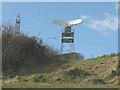
H M Coastguard Station at Langdon Cliffs, Dover
Image: © Ian S
Taken: 11 Feb 2020
0.01 miles
2
H M Coastguard Station at Langdon Cliffs, Dover
Image: © Ian S
Taken: 11 Feb 2020
0.01 miles

4
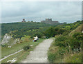
Towards coastguard station overlooking the Straits of Dover
Image: © Andrew Tatlow
Taken: 20 Feb 2010
0.02 miles


7
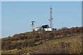
Coastguard radar station, Dover (2)
A close-up of Image
Image: © Stephen Craven
Taken: 1 Mar 2008
0.05 miles
8
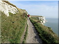
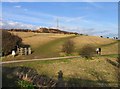
Saxon Shore Way high above Langdon Bay
Perched on a shelf above the chalk cliffs, the long distance footpath is lifted high above the sea below. The coastguard station is obscured from view by the white cliff wall on the left.
Image: © Chris Heaton
Taken: 18 Oct 2013
0.05 miles