IMAGES TAKEN NEAR TO
The Street, DOVER, CT15 5JP
Introduction
This page details the photographs taken nearby to The Street, CT15 5JP by members of the Geograph project.
The Geograph project started in 2005 with the aim of publishing, organising and preserving representative images for every square kilometre of Great Britain, Ireland and the Isle of Man.

There are currently over 7.5m images from over14,400 individuals and you can help contribute to the project by visiting https://www.geograph.org.uk
Image Map
Images are licensed for reuse under creativecommons.org/licenses/by-sa/2.0
Notes
- Clicking on the map will re-center to the selected point.
- The higher the marker number, the further away the image location is from the centre of the postcode.
Image Listing (41 Images Found)
Images are licensed for reuse under creativecommons.org/licenses/by-sa/2.0
Image
Details
Distance
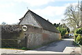
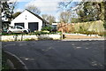
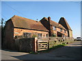
1
The Street, Martin
Twentieth-century houses along the left hand side of the road; the first being called Dolphin Cottage.
Image: © John Baker
Taken: 30 Dec 2012
0.01 miles
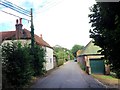
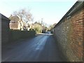
5
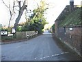
View along The Street, Martin
Martin is a small village in the parish of East Langdon and was owned by Langdon Abbey until the Reformation in 1530. There has been a settlement at Martin since Anglo Saxon times. In AD 861 it was listed as Mereton, meaning "farmstead by the pools".
Image: © Nick Smith
Taken: 1 Dec 2007
0.02 miles