IMAGES TAKEN NEAR TO
East Langdon, DOVER, CT15 5JB
Introduction
This page details the photographs taken nearby to CT15 5JB by members of the Geograph project.
The Geograph project started in 2005 with the aim of publishing, organising and preserving representative images for every square kilometre of Great Britain, Ireland and the Isle of Man.

There are currently over 7.5m images from over14,400 individuals and you can help contribute to the project by visiting https://www.geograph.org.uk
Image Map
Images are licensed for reuse under creativecommons.org/licenses/by-sa/2.0
Notes
- Clicking on the map will re-center to the selected point.
- The higher the marker number, the further away the image location is from the centre of the postcode.
Image Listing (8 Images Found)
Images are licensed for reuse under creativecommons.org/licenses/by-sa/2.0
Image
Details
Distance
2
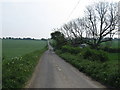
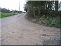
Solton Lane towards the A258
This lane leads from East Langdon, past Solton Manor Cottages (on the right) towards the Dover / Deal road.
Image: © David Anstiss
Taken: 24 Apr 2011
0.01 miles


8
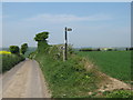
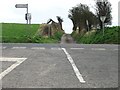
Bridleway junction on Pond Lane
Pond Lane leads from West Cliff on Dover Road, towards the A258 Road. The bridleway leads right towards Station Road.
Image: © David Anstiss
Taken: 24 Apr 2011
0.24 miles