IMAGES TAKEN NEAR TO
Roman Road, DOVER, CT15 5HR
Introduction
This page details the photographs taken nearby to Roman Road, CT15 5HR by members of the Geograph project.
The Geograph project started in 2005 with the aim of publishing, organising and preserving representative images for every square kilometre of Great Britain, Ireland and the Isle of Man.

There are currently over 7.5m images from over14,400 individuals and you can help contribute to the project by visiting https://www.geograph.org.uk
Image Map
Images are licensed for reuse under creativecommons.org/licenses/by-sa/2.0
Notes
- Clicking on the map will re-center to the selected point.
- The higher the marker number, the further away the image location is from the centre of the postcode.
Image Listing (9 Images Found)
Images are licensed for reuse under creativecommons.org/licenses/by-sa/2.0
Image
Details
Distance
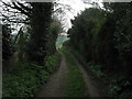
2
The North Downs Way heading towards Ashley
Image: © Tim Heaton
Taken: 9 Aug 2019
0.21 miles
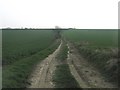
3
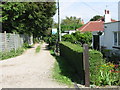
North Downs Way to Ashley (2)
The long distance path leads through a field, then along a hedge lined path from Roman Road, towards the village (in the background).
Image: © David Anstiss
Taken: 27 Mar 2011
0.21 miles
4
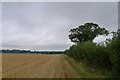
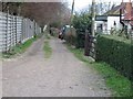
North Downs Way leaves Ashley
The long distance path leaves the village, and heads through several fields towards Roman Road, near Maydensole Farm.
Image: © David Anstiss
Taken: 27 Mar 2011
0.22 miles
5
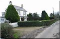
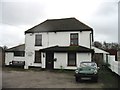
Three bungalows on a track off Roman Road
Similar view to http://www.geograph.org.uk/photo/346592 with some summer colour.
Image: © Nick Smith
Taken: 13 Sep 2008
0.23 miles
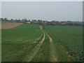
9
North Downs Way near Ashley
The long distance path leads from Chapel Lane in the village, through a large field towards Roman Road near Maydensole Farm.
Image: © David Anstiss
Taken: 27 Mar 2011
0.25 miles