IMAGES TAKEN NEAR TO
The Lane, DOVER, CT15 5ES
Introduction
This page details the photographs taken nearby to The Lane, CT15 5ES by members of the Geograph project.
The Geograph project started in 2005 with the aim of publishing, organising and preserving representative images for every square kilometre of Great Britain, Ireland and the Isle of Man.

There are currently over 7.5m images from over14,400 individuals and you can help contribute to the project by visiting https://www.geograph.org.uk
Image Map
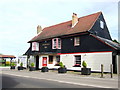
Images are licensed for reuse under creativecommons.org/licenses/by-sa/2.0
Notes
- Clicking on the map will re-center to the selected point.
- The higher the marker number, the further away the image location is from the centre of the postcode.
Image Listing (12 Images Found)
Images are licensed for reuse under creativecommons.org/licenses/by-sa/2.0
Image
Details
Distance
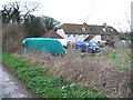
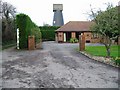
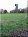
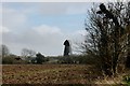
4
Guston Mill
Landmark old mill at Guston, now residential and with no sails.
Image: © Colin Smith
Taken: 21 Apr 2011
0.08 miles
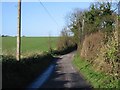
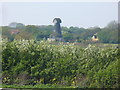
8
View across the fields from Hangman's Lane
Image: © Nick Smith
Taken: 1 Dec 2007
0.20 miles
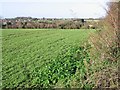
10

Route of dismantled railway
The line of trees on the left hand side of the field marks the route of the railway which had just crossed over a road see http://www.geograph.org.uk/photo/2024903 In the distance are two masts near to Upper Road, inland from Langdon Cliffs.
Image: © John Baker
Taken: 20 Aug 2010
0.21 miles