IMAGES TAKEN NEAR TO
Guston, DOVER, CT15 5EB
Introduction
This page details the photographs taken nearby to CT15 5EB by members of the Geograph project.
The Geograph project started in 2005 with the aim of publishing, organising and preserving representative images for every square kilometre of Great Britain, Ireland and the Isle of Man.

There are currently over 7.5m images from over14,400 individuals and you can help contribute to the project by visiting https://www.geograph.org.uk
Image Map
Images are licensed for reuse under creativecommons.org/licenses/by-sa/2.0
Notes
- Clicking on the map will re-center to the selected point.
- The higher the marker number, the further away the image location is from the centre of the postcode.
Image Listing (8 Images Found)
Images are licensed for reuse under creativecommons.org/licenses/by-sa/2.0
Image
Details
Distance
1
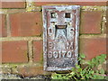
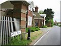
Ordnance Survey Flush Bracket S6170
This can be found on the Chapel wall at the Duke of York's Royal Military School.
For more detail see : http://www.bench-marks.org.uk/bm13883
Image: © Peter Wood
Taken: 15 Feb 2016
0.12 miles
3
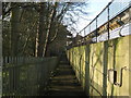
Footpath to Dover Road
This path leads from the A258 Deal Road, past the Duke of York Pub / Restaurant and Total Petrol Filling Station, then the path leads past a Premier Inn motel (on the right) along the A2, before heading towards the road.
Image: © David Anstiss
Taken: 20 Mar 2011
0.22 miles
5
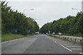
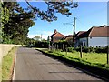
View along Dover Road and Duke of York Military School side entrance.
Image: © Nick Smith
Taken: 5 May 2007
0.24 miles
7
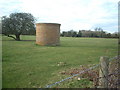
Ventilation shaft near Guston
This is a ventilation shaft for the railway tunnel on the Dover - Ramsgate line.
Image: © Rosie Burnham
Taken: 17 Feb 2006
0.24 miles
8
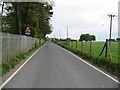
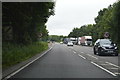
Looking S along Dover Road
Note the brick built air shaft chimney by the second telegraph pole, shown in detail in the first geograph.
Image: © Nick Smith
Taken: 5 May 2007
0.25 miles