IMAGES TAKEN NEAR TO
Deal Road, DOVER, CT15 5DP
Introduction
This page details the photographs taken nearby to Deal Road, CT15 5DP by members of the Geograph project.
The Geograph project started in 2005 with the aim of publishing, organising and preserving representative images for every square kilometre of Great Britain, Ireland and the Isle of Man.

There are currently over 7.5m images from over14,400 individuals and you can help contribute to the project by visiting https://www.geograph.org.uk
Image Map
Images are licensed for reuse under creativecommons.org/licenses/by-sa/2.0
Notes
- Clicking on the map will re-center to the selected point.
- The higher the marker number, the further away the image location is from the centre of the postcode.
Image Listing (8 Images Found)
Images are licensed for reuse under creativecommons.org/licenses/by-sa/2.0
Image
Details
Distance
6
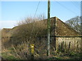
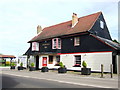
Old Flint Barn
Part of the buildings of Bere Farm.
Seen from the footpath passing the farm.
Image: © David Anstiss
Taken: 20 Mar 2011
0.20 miles
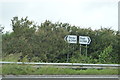
8

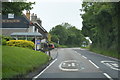
Dover Road onto A258
Left to Dover and right to Walmer and Deal.
Image: © Oast House Archive
Taken: 24 Jul 2010
0.22 miles