IMAGES TAKEN NEAR TO
Sutton, DOVER, CT15 5DJ
Introduction
This page details the photographs taken nearby to CT15 5DJ by members of the Geograph project.
The Geograph project started in 2005 with the aim of publishing, organising and preserving representative images for every square kilometre of Great Britain, Ireland and the Isle of Man.

There are currently over 7.5m images from over14,400 individuals and you can help contribute to the project by visiting https://www.geograph.org.uk
Image Map
Images are licensed for reuse under creativecommons.org/licenses/by-sa/2.0
Notes
- Clicking on the map will re-center to the selected point.
- The higher the marker number, the further away the image location is from the centre of the postcode.
Image Listing (5 Images Found)
Images are licensed for reuse under creativecommons.org/licenses/by-sa/2.0
Image
Details
Distance
1
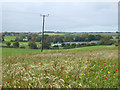
View towards Wingleton Farm
The flowery field corner in the foreground appears to have been deliberately left.
Image: © Robin Webster
Taken: 14 Oct 2017
0.09 miles
4
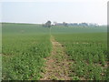
Footpath to Pommeus Lane
A path leads from Forge Lane in Sutton, towards Wingleton Farm (in the background), before heading towards the lane near Ripple.
Image: © David Anstiss
Taken: 27 Mar 2011
0.22 miles
5
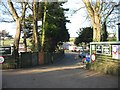
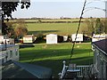
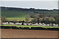
Entrance to Sutton Vale country club and caravan park
Image: © Nick Smith
Taken: 16 Dec 2007
0.25 miles