IMAGES TAKEN NEAR TO
Waldershare, DOVER, CT15 5BG
Introduction
This page details the photographs taken nearby to CT15 5BG by members of the Geograph project.
The Geograph project started in 2005 with the aim of publishing, organising and preserving representative images for every square kilometre of Great Britain, Ireland and the Isle of Man.

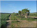
There are currently over 7.5m images from over14,400 individuals and you can help contribute to the project by visiting https://www.geograph.org.uk
Image Map
Images are licensed for reuse under creativecommons.org/licenses/by-sa/2.0
Notes
- Clicking on the map will re-center to the selected point.
- The higher the marker number, the further away the image location is from the centre of the postcode.
Image Listing (14 Images Found)
Images are licensed for reuse under creativecommons.org/licenses/by-sa/2.0
Image
Details
Distance
1

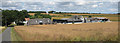
Malmains Farm
Looking across towards the centre of the square from the SE corner.
Image: © Chris Shaw
Taken: 13 Aug 2006
0.03 miles
5
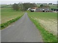
Malmains Farm
As seen from the bridleway and footpath near the farm.
On the left is a farm cottage.
Image: © David Anstiss
Taken: 23 May 2011
0.07 miles
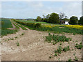
6
Bridleway and footpath junction near Malmains Farm
A footpath leads straight on from Kennel Hill, towards Barville Farm on Barville Road. It crosses a bridleway heading right towards Malmains Farm and Sandwich Road, from Green Lane in Eythorne.
Note: the symbol marker shows two blue bridleway markers instead of one blue and one yellow footpath marker!
Image: © David Anstiss
Taken: 23 May 2011
0.08 miles
7
Track past Malmains Farm
Malmains Farmhouse is a grade II listed building that dates from the 15th century but was altered and extended in the mid 17th century and c1800. The house was the principal seat of the Monins family and the manor house, until Sir Henry Furnese purchased the estate and built Waldershare Park c1705. http://www.britishlistedbuildings.co.uk/en-429077-malmains-farmhouse-and-shareborne-house-#.VXsgLv7bLcc The track also serves as a footpath.
Image: © John Baker
Taken: 10 May 2015
0.10 miles
8
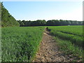
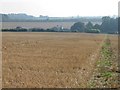
Footpath to Kettle Hill
This path leads from Barville Road, past Barville Farm and Malmains Farm before heading towards Kettle Hill (road).
In the background is Malmains Wood.
Image: © David Anstiss
Taken: 23 May 2011
0.14 miles
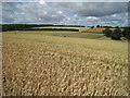
10
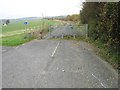
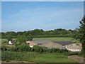
Gate across the old A256
This section of the old A256 is part of a cycle route now, it was once the main road from Dover to Thanet. The new A256 runs parallel, just to the right of the photo.
Image: © Nick Smith
Taken: 18 Nov 2007
0.15 miles