IMAGES TAKEN NEAR TO
Holt Street, DOVER, CT15 4LP
Introduction
This page details the photographs taken nearby to Holt Street, CT15 4LP by members of the Geograph project.
The Geograph project started in 2005 with the aim of publishing, organising and preserving representative images for every square kilometre of Great Britain, Ireland and the Isle of Man.

There are currently over 7.5m images from over14,400 individuals and you can help contribute to the project by visiting https://www.geograph.org.uk
Image Map
Images are licensed for reuse under creativecommons.org/licenses/by-sa/2.0
Notes
- Clicking on the map will re-center to the selected point.
- The higher the marker number, the further away the image location is from the centre of the postcode.
Image Listing (14 Images Found)
Images are licensed for reuse under creativecommons.org/licenses/by-sa/2.0
Image
Details
Distance
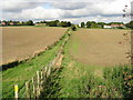
3
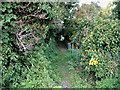
Houses on Holt Street from footpath
This is the rear of the houses on Holt Street as seen from the footpath which follows the field edge. It isn't clear at this point where the path passes onto the road.
Image: © Nick Smith
Taken: 2 Oct 2008
0.02 miles
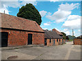
6
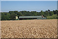
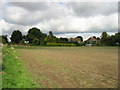
Barn at Holtstreet Farm
Looking across wheat field off Butler Street.
Image: © Oast House Archive
Taken: 22 Jul 2010
0.05 miles
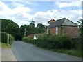
7
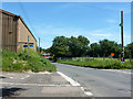
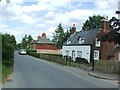
Holt Street looking towards Nonington
Butter Street comes in from the left, with Nightingale Lane opposite.
Image: © Robin Webster
Taken: 4 Jun 2015
0.08 miles