IMAGES TAKEN NEAR TO
Beauchamps Lane, DOVER, CT15 4LN
Introduction
This page details the photographs taken nearby to Beauchamps Lane, CT15 4LN by members of the Geograph project.
The Geograph project started in 2005 with the aim of publishing, organising and preserving representative images for every square kilometre of Great Britain, Ireland and the Isle of Man.

There are currently over 7.5m images from over14,400 individuals and you can help contribute to the project by visiting https://www.geograph.org.uk
Image Map
Images are licensed for reuse under creativecommons.org/licenses/by-sa/2.0
Notes
- Clicking on the map will re-center to the selected point.
- The higher the marker number, the further away the image location is from the centre of the postcode.
Image Listing (21 Images Found)
Images are licensed for reuse under creativecommons.org/licenses/by-sa/2.0
Image
Details
Distance
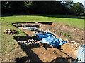
1
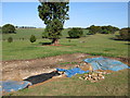
Archaeological dig near Nonington Court
Possibly the remains of a mediaeval manor house, much of the flint and brick has been robbed out.
Image: © Nick Smith
Taken: 12 Oct 2009
0.13 miles
2
Archaeological dig near Nonington Court
Possibly the foundations of a mediaeval manor house
Image: © Nick Smith
Taken: 12 Oct 2009
0.13 miles
3
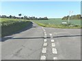
The junction of Pinners Hill with Pinners Lane
With the church tower of St Mary the Virgin in the distance.
Image: © John Baker
Taken: 30 Oct 2013
0.15 miles
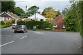
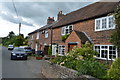
7
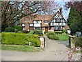
House at junction of Beauchamps Lane and Easole Street
Image: © Nick Smith
Taken: 14 Apr 2007
0.20 miles