IMAGES TAKEN NEAR TO
Park View Rise, DOVER, CT15 4JS
Introduction
This page details the photographs taken nearby to Park View Rise, CT15 4JS by members of the Geograph project.
The Geograph project started in 2005 with the aim of publishing, organising and preserving representative images for every square kilometre of Great Britain, Ireland and the Isle of Man.

There are currently over 7.5m images from over14,400 individuals and you can help contribute to the project by visiting https://www.geograph.org.uk
Image Map
Images are licensed for reuse under creativecommons.org/licenses/by-sa/2.0
Notes
- Clicking on the map will re-center to the selected point.
- The higher the marker number, the further away the image location is from the centre of the postcode.
Image Listing (57 Images Found)
Images are licensed for reuse under creativecommons.org/licenses/by-sa/2.0
Image
Details
Distance
5
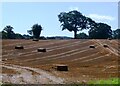
All is safely gathered in, Nonington
Harvested field off Easole Street.
Image: © pam fray
Taken: 23 Aug 2023
0.04 miles
6
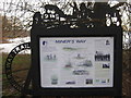
The Miner's Way Noticeboard
On Easole Street in Nonington.
Shows the route of the 28 mile circular long distance path in East Kent.
Image: © David Anstiss
Taken: 26 Dec 2010
0.04 miles