IMAGES TAKEN NEAR TO
Nightingale Lane, DOVER, CT15 4JD
Introduction
This page details the photographs taken nearby to Nightingale Lane, CT15 4JD by members of the Geograph project.
The Geograph project started in 2005 with the aim of publishing, organising and preserving representative images for every square kilometre of Great Britain, Ireland and the Isle of Man.

There are currently over 7.5m images from over14,400 individuals and you can help contribute to the project by visiting https://www.geograph.org.uk
Image Map
Images are licensed for reuse under creativecommons.org/licenses/by-sa/2.0
Notes
- Clicking on the map will re-center to the selected point.
- The higher the marker number, the further away the image location is from the centre of the postcode.
Image Listing (8 Images Found)
Images are licensed for reuse under creativecommons.org/licenses/by-sa/2.0
Image
Details
Distance
1
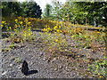
Rusty Barn near Snowdown
This ruined barn is on the edge of the waste rock tip from Snowdown Mine.
Whether it was anything to do with the mine I don't know.
Image: © Des Blenkinsopp
Taken: 27 Aug 2011
0.08 miles
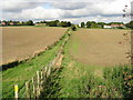
2
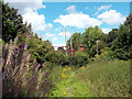
Wild Flowers on the Coal Tip
Twenty five years after mining ceased at Snowdown Colliery, the waste tip which covers a big patch of land to the SE of the mine is gradually growing over. Some is still bare stone but parts are now healthy young woodland.
That's a lump of coal I put in front there.
Image: © Des Blenkinsopp
Taken: 27 Aug 2011
0.14 miles
3
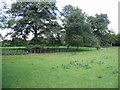
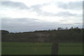
Looking NW along footpath
The line of the footpath was difficult to find until you find the stile which can just be seen to the left of the two trees on the fence line
Image: © Nick Smith
Taken: 2 Oct 2008
0.16 miles
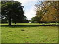
4
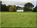
Little Fredville, house in Fredville Park
Image: © Nick Smith
Taken: 2 Oct 2008
0.19 miles