IMAGES TAKEN NEAR TO
Mill Top, DOVER, CT15 4HW
Introduction
This page details the photographs taken nearby to Mill Top, CT15 4HW by members of the Geograph project.
The Geograph project started in 2005 with the aim of publishing, organising and preserving representative images for every square kilometre of Great Britain, Ireland and the Isle of Man.

There are currently over 7.5m images from over14,400 individuals and you can help contribute to the project by visiting https://www.geograph.org.uk
Image Map
Images are licensed for reuse under creativecommons.org/licenses/by-sa/2.0
Notes
- Clicking on the map will re-center to the selected point.
- The higher the marker number, the further away the image location is from the centre of the postcode.
Image Listing (6 Images Found)
Images are licensed for reuse under creativecommons.org/licenses/by-sa/2.0
Image
Details
Distance
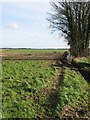
1
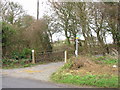
Farm entrance and Footpath opposite E end Mill Lane
Image: © Nick Smith
Taken: 7 Jan 2007
0.06 miles
2
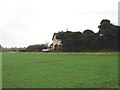
Houses viewed from top of Mill Lane, Nonington.
Image: © Nick Smith
Taken: 7 Jan 2007
0.07 miles
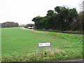
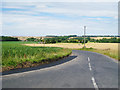
5
Field boundary adjacent to the road to Elvington
Looking in the opposite direction to http://www.geograph.org.uk/photo/649371
Image: © Nick Smith
Taken: 2 Feb 2008
0.21 miles