IMAGES TAKEN NEAR TO
Gooseberry Hall Lane, DOVER, CT15 4HJ
Introduction
This page details the photographs taken nearby to Gooseberry Hall Lane, CT15 4HJ by members of the Geograph project.
The Geograph project started in 2005 with the aim of publishing, organising and preserving representative images for every square kilometre of Great Britain, Ireland and the Isle of Man.

There are currently over 7.5m images from over14,400 individuals and you can help contribute to the project by visiting https://www.geograph.org.uk
Image Map
Images are licensed for reuse under creativecommons.org/licenses/by-sa/2.0
Notes
- Clicking on the map will re-center to the selected point.
- The higher the marker number, the further away the image location is from the centre of the postcode.
Image Listing (21 Images Found)
Images are licensed for reuse under creativecommons.org/licenses/by-sa/2.0
Image
Details
Distance
1
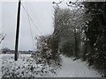
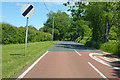
Cherrygarden Lane
This named byway leads from Love Lane, past Gooseberryhall Wood and Gooseberryhall Farm before heading towards Sandwich Road.
Image: © David Anstiss
Taken: 19 Dec 2010
0.08 miles
2
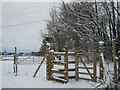
Kissing gate near Cherrygarden Lane
This gate is on a footpath from Sandwich Road to the byway near Gooseberryhall Farm. A bridleway leads from the byway towards Yew Tree Farm, Chillenden.
Image: © David Anstiss
Taken: 19 Dec 2010
0.12 miles
3
Footpath enters the woods from St Alban's Down
Image: © Nick Smith
Taken: 10 Jan 2009
0.13 miles
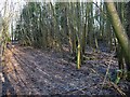
4
Footpath through the woods from St Alban's Downs
The path is more obvious than the photo implies, the stake marks the route.
Image: © Nick Smith
Taken: 10 Jan 2009
0.13 miles
5
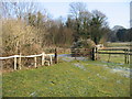
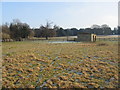
Footpath on St Alban's Down
It is difficult to find the path in the rough grass but it enters the woodland just beyond the shed.
Image: © Nick Smith
Taken: 10 Jan 2009
0.13 miles
6
Footpath on St Alban's Down
Difficult to follow the path across the rough pasture but it enters the woodland by the gate on the left of the photo.
Image: © Nick Smith
Taken: 10 Jan 2009
0.13 miles
7
Path through the woods to St Alban's Downs
Image: © Nick Smith
Taken: 10 Jan 2009
0.13 miles
9
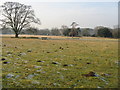
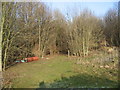
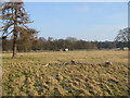
View across St Alban's Down
Pockets of frost remained in the tufts of grass away from the sun.
Image: © Nick Smith
Taken: 10 Jan 2009
0.15 miles
10
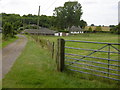
Looking along Cherrygarden Lane towards Gooseberryhall Farm
Gooseberryhall Farm belongs to the Bruderhof Community who are based at nearby Beech Grove at Nonington - see http://www.bruderhof.com/en/where-we-are/united-kingdom/beech-grove
Image: © Marathon
Taken: 8 Jul 2016
0.16 miles