IMAGES TAKEN NEAR TO
Terrace Road, DOVER, CT15 4EH
Introduction
This page details the photographs taken nearby to Terrace Road, CT15 4EH by members of the Geograph project.
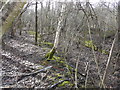
The Geograph project started in 2005 with the aim of publishing, organising and preserving representative images for every square kilometre of Great Britain, Ireland and the Isle of Man.

There are currently over 7.5m images from over14,400 individuals and you can help contribute to the project by visiting https://www.geograph.org.uk
Image Map
Images are licensed for reuse under creativecommons.org/licenses/by-sa/2.0
Notes
- Clicking on the map will re-center to the selected point.
- The higher the marker number, the further away the image location is from the centre of the postcode.
Image Listing (21 Images Found)
Images are licensed for reuse under creativecommons.org/licenses/by-sa/2.0
Image
Details
Distance
1
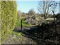
Sawn off lengths of original bullhead rail
Seen from the end of a footpath from Terrace Road and mentioned in the http://www.disused-stations.org.uk/e/elvington/index.shtml these had been used on the EKLR (East Kent Light railway) as a vehicle barrier at the start of Burgess Hill.
Image: © John Baker
Taken: 27 Feb 2015
0.02 miles
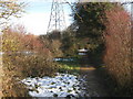
2
Burgess Hill
This path leads from Elvington to Pike Road (and the industrial works).
Image: © David Anstiss
Taken: 26 Dec 2010
0.04 miles
3
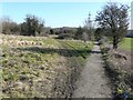
Looking southwest along Terrace Road
The railing (one of two) is at the end of a footpath, put there as a safety measure.
Image: © John Baker
Taken: 27 Feb 2015
0.05 miles
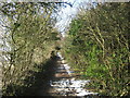
4
Path down Burgess Hill
This is the path that coal miners, living at Elvington and employed at Tilmanstone Colliery, would have walked along to catch at train from Elvington station. This was opened on 16 October 1916, closed to passengers on 1 November 1948 and closed completely on 1 March 1951
http://www.disused-stations.org.uk/e/elvington/index.shtml This view may change sometime in the future as planning permission has been granted by Dover District Council under application number DOV/13/00654, for “A) full application for the re-contouring of the spoil and restoration of the former Colliery, proposed siting of a photovoltaic array (10 MW), restoration of the former railway halt including siting a visitor interpretation boards and rock store, landscaping and ecological works and footpath link and B) outline application for the siting of industrial units (Class B2) (10,000 sq m GEA) with all matters reserved, with the exception of layout, scale, associated car parking and means of access (amended and additional details)”. This is a similar scheme to that found near Betteshanger, which has now become Fowlmead Country Park Image
Image: © John Baker
Taken: 27 Feb 2015
0.07 miles
5
Burgess Hill (2)
This path leads from Terrace Road, Elvington towards the Industrial Works on Pike Road.
Image: © David Anstiss
Taken: 26 Dec 2010
0.11 miles
6
Burgess Hill (3)
This path leads from the Industrial works and factories on Pike Road, uphill towards Terrace Road, Elvington.
Image: © David Anstiss
Taken: 26 Dec 2010
0.15 miles
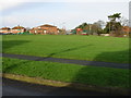
7
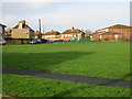
View across the green to St John's Road from Fairview Road
Image: © Nick Smith
Taken: 5 Jan 2008
0.17 miles
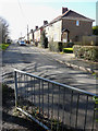
8
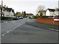
View along Milner Road from junction with St John's Road
Elvington was originally built in the early part of the 20th Century as a mining village to serve the neighbouring Tilmanstone colliery which finally closed in 1986.
Image: © Nick Smith
Taken: 5 Jan 2008
0.19 miles
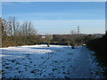
10
The remains of Elvington station platform
The station was opened on 16 October 1916, closed to passengers on 1 November 1948 and closed completely on 1 March 1951
http://www.disused-stations.org.uk/e/elvington/index.shtml
Planning permission has been granted by Dover District Council under application number DOV/13/00654 for “A) full application for the re-contouring of the spoil and restoration of the former Colliery, proposed siting of a photovoltaic array (10 MW), restoration of the former railway halt including siting a visitor interpretation boards and rock store, landscaping and ecological works and footpath link and B) outline application for the siting of industrial units (Class B2) (10,000 sq m GEA) with all matters reserved, with the exception of layout, scale, associated car parking and means of access (amended and additional details)”. This is a similar scheme to that found near Betteshanger, which has now become Fowlmead Country Park in Image
A further exploration of the application relating to the halt, revealed that a short length of track is to be layed in the cutting, beside and beyond the platform (which is shown in this view from the top of the cutting). It cannot be very long as the trackbed towards Eastry lies buried under the spoil heap created by Tilmanstone Colliery, a little way beyond the platform.
Image: © John Baker
Taken: 22 Feb 2015
0.20 miles