IMAGES TAKEN NEAR TO
Summer Meadow, CT14 9WQ
Introduction
This page details the photographs taken nearby to Summer Meadow, CT14 9WQ by members of the Geograph project.
The Geograph project started in 2005 with the aim of publishing, organising and preserving representative images for every square kilometre of Great Britain, Ireland and the Isle of Man.

There are currently over 7.5m images from over14,400 individuals and you can help contribute to the project by visiting https://www.geograph.org.uk
Image Map
Images are licensed for reuse under creativecommons.org/licenses/by-sa/2.0
Notes
- Clicking on the map will re-center to the selected point.
- The higher the marker number, the further away the image location is from the centre of the postcode.
Image Listing (58 Images Found)
Images are licensed for reuse under creativecommons.org/licenses/by-sa/2.0
Image
Details
Distance
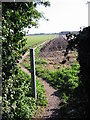
1
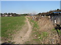
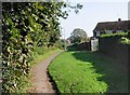
Unofficial path to Sholden?
Not marked as a path on the map, this is clearly used as a path, running along the back of the allotments off Church Lane path.
Image: © Nick Smith
Taken: 17 Feb 2008
0.05 miles
2
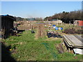
The allotments off Church Lane path
The allotments are on the corner of the junction of Church Lane path and Grantham Avenue.
Image: © Nick Smith
Taken: 17 Feb 2008
0.06 miles
4
Church Lane path
Looking SW towards Sholden church.
Image: © Nick Smith
Taken: 17 Feb 2008
0.07 miles
6
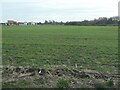
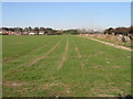
Farmland east of Sholden
Nearly, but not quite, squeezed out by a new housing estate on the edge of Deal.
Image: © Christine Johnstone
Taken: 17 Feb 2022
0.09 miles
8
Public footpath heading east from Sholden
This path is shown on the large scale OS map surveyed in 1871-2.
Image: © Christine Johnstone
Taken: 17 Feb 2022
0.14 miles
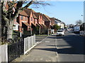
9
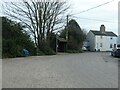
Bus stop, 'The Street', Sholden
The large scale OS map from the 1890s shows a narrow lane crossing through a pond at the corner here. The only clue now is how wide the road is.
Image: © Christine Johnstone
Taken: 17 Feb 2022
0.15 miles
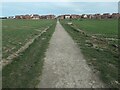
10
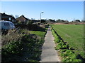
Looking E along footpath, Sholden
The footpath leads from New Street Sholden to Church Lane.
Image: © Nick Smith
Taken: 14 Oct 2007
0.15 miles