IMAGES TAKEN NEAR TO
Birdwood Avenue, DEAL, CT14 9SF
Introduction
This page details the photographs taken nearby to Birdwood Avenue, CT14 9SF by members of the Geograph project.
The Geograph project started in 2005 with the aim of publishing, organising and preserving representative images for every square kilometre of Great Britain, Ireland and the Isle of Man.

There are currently over 7.5m images from over14,400 individuals and you can help contribute to the project by visiting https://www.geograph.org.uk
Image Map
Images are licensed for reuse under creativecommons.org/licenses/by-sa/2.0
Notes
- Clicking on the map will re-center to the selected point.
- The higher the marker number, the further away the image location is from the centre of the postcode.
Image Listing (107 Images Found)
Images are licensed for reuse under creativecommons.org/licenses/by-sa/2.0
Image
Details
Distance
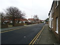
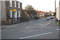
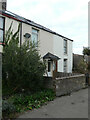
5
Row on Middle Deal Road
367 - 377 odds.
Image: © Robin Webster
Taken: 14 Oct 2017
0.10 miles
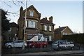
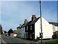
8
222, Church Path
Planning permission has been granted by Dover District Council under application number DOV/20/00967 for the “erection of a front dormer roof extension”.
The house has been fitted with a satellite dish.
Image: © John Baker
Taken: 18 Oct 2020
0.12 miles
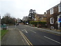
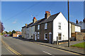
9
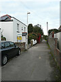
Church Path
This part of Church Path can be accessed from London Road (A258).
Image: © John Baker
Taken: 18 Oct 2020
0.12 miles