IMAGES TAKEN NEAR TO
Addelam Close, DEAL, CT14 9LT
Introduction
This page details the photographs taken nearby to Addelam Close, CT14 9LT by members of the Geograph project.
The Geograph project started in 2005 with the aim of publishing, organising and preserving representative images for every square kilometre of Great Britain, Ireland and the Isle of Man.

There are currently over 7.5m images from over14,400 individuals and you can help contribute to the project by visiting https://www.geograph.org.uk
Image Map
Images are licensed for reuse under creativecommons.org/licenses/by-sa/2.0
Notes
- Clicking on the map will re-center to the selected point.
- The higher the marker number, the further away the image location is from the centre of the postcode.
Image Listing (71 Images Found)
Images are licensed for reuse under creativecommons.org/licenses/by-sa/2.0
Image
Details
Distance
2
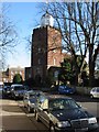
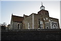
St Leonard's Church, Upper Deal
The parish church of Deal and, for centuries, the only church in Deal, St Leonard's dates back to the 12th century.
Image: © Nick Smith
Taken: 17 Feb 2008
0.04 miles
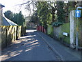
5
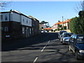
Looking W along Rectory Road, Upper Deal
Image: © Nick Smith
Taken: 17 Feb 2008
0.06 miles
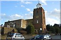
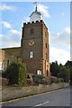
6
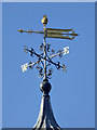
Weather vane, St. Leonard's, Deal
Surmounted by a bishop's mitre.
Image: © Robin Webster
Taken: 14 Oct 2017
0.06 miles
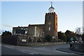
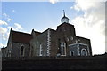
7
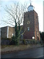
St. Leonard's Church, Upper Deal
St. Leonard's is the parish church of Deal. For centuries, before the building of St. George's Church in the town centre, it was the only church in the town.
Image: © Rosie Burnham
Taken: 16 Feb 2006
0.06 miles