IMAGES TAKEN NEAR TO
Cross Road, DEAL, CT14 9LB
Introduction
This page details the photographs taken nearby to Cross Road, CT14 9LB by members of the Geograph project.
The Geograph project started in 2005 with the aim of publishing, organising and preserving representative images for every square kilometre of Great Britain, Ireland and the Isle of Man.

There are currently over 7.5m images from over14,400 individuals and you can help contribute to the project by visiting https://www.geograph.org.uk
Image Map (Loading...)


Getting Data...Please wait
Leaflet Map data © OpenStreetMap
Images are licensed for reuse under creativecommons.org/licenses/by-sa/2.0
Notes
- Clicking on the map will re-center to the selected point.
- The higher the marker number, the further away the image location is from the centre of the postcode.
Image Listing (22 Images Found)
Images are licensed for reuse under creativecommons.org/licenses/by-sa/2.0
Image
Details
Distance
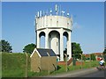
2
Water Tower and Reservoir
A Southern Water site along St Richards Road.
Image: © Des Blenkinsopp
Taken: 12 Jun 2021
0.11 miles
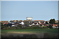
4
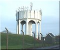
Water Tower, Walmer
The water tower sits at the highest point in Deal and Walmer, overlooking Mill Hill. It is owned by Southern Water.
Image: © Rosie Burnham
Taken: 16 Feb 2006
0.12 miles
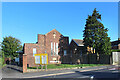
10
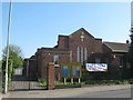
St. Richard's Church Centre, Walmer
On Mill Hill.
Image: © David Anstiss
Taken: 17 Apr 2011
0.14 miles