IMAGES TAKEN NEAR TO
Douglas Road, DEAL, CT14 9HT
Introduction
This page details the photographs taken nearby to Douglas Road, CT14 9HT by members of the Geograph project.
The Geograph project started in 2005 with the aim of publishing, organising and preserving representative images for every square kilometre of Great Britain, Ireland and the Isle of Man.

There are currently over 7.5m images from over14,400 individuals and you can help contribute to the project by visiting https://www.geograph.org.uk
Image Map
Images are licensed for reuse under creativecommons.org/licenses/by-sa/2.0
Notes
- Clicking on the map will re-center to the selected point.
- The higher the marker number, the further away the image location is from the centre of the postcode.
Image Listing (21 Images Found)
Images are licensed for reuse under creativecommons.org/licenses/by-sa/2.0
Image
Details
Distance
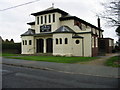
3
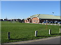
Clubhouse for sportsground off Cavell Square
Image: © Nick Smith
Taken: 17 Feb 2008
0.14 miles
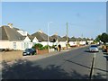
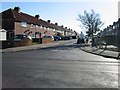
7
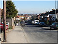
Looking NE along Mill Hill
The sea can just be seen at the horizon, a line of deeper blue.
Image: © Nick Smith
Taken: 17 Feb 2008
0.17 miles