IMAGES TAKEN NEAR TO
Trinity Place, DEAL, CT14 9HJ
Introduction
This page details the photographs taken nearby to Trinity Place, CT14 9HJ by members of the Geograph project.
The Geograph project started in 2005 with the aim of publishing, organising and preserving representative images for every square kilometre of Great Britain, Ireland and the Isle of Man.

There are currently over 7.5m images from over14,400 individuals and you can help contribute to the project by visiting https://www.geograph.org.uk
Image Map (Loading...)


Getting Data...Please wait
Leaflet Map data © OpenStreetMap
Images are licensed for reuse under creativecommons.org/licenses/by-sa/2.0
Notes
- Clicking on the map will re-center to the selected point.
- The higher the marker number, the further away the image location is from the centre of the postcode.
Image Listing (67 Images Found)
Images are licensed for reuse under creativecommons.org/licenses/by-sa/2.0
Image
Details
Distance
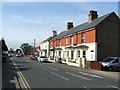
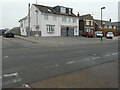
1
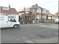
41 Manor Road, Upper Deal
Planning permission has been granted by Dover District Council under application number DOV/12/00819 for the “erection of a two storey side and single storey rear extension”.
Image: © John Baker
Taken: 27 Jan 2014
0.07 miles
5
Lucy's, 22, Mill Hill
The premises is a beauty salon.
Image: © John Baker
Taken: 12 Feb 2023
0.13 miles
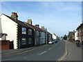
6
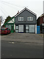
40, Mill Hill
This was the premises of the bookmakers Coral.
Image: © John Baker
Taken: 12 Feb 2023
0.13 miles