IMAGES TAKEN NEAR TO
Leas Road, DEAL, CT14 9AR
Introduction
This page details the photographs taken nearby to Leas Road, CT14 9AR by members of the Geograph project.
The Geograph project started in 2005 with the aim of publishing, organising and preserving representative images for every square kilometre of Great Britain, Ireland and the Isle of Man.

There are currently over 7.5m images from over14,400 individuals and you can help contribute to the project by visiting https://www.geograph.org.uk
Image Map
Images are licensed for reuse under creativecommons.org/licenses/by-sa/2.0
Notes
- Clicking on the map will re-center to the selected point.
- The higher the marker number, the further away the image location is from the centre of the postcode.
Image Listing (41 Images Found)
Images are licensed for reuse under creativecommons.org/licenses/by-sa/2.0
Image
Details
Distance
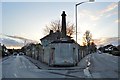
9
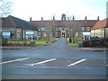
Victoria Hospital, Deal
Officially opened in 1924, Victoria Hospital in Deal was built as a permanent memorial to those who lost their lives during the First and Second World Wars.
Image: © Rosie Burnham
Taken: 16 Feb 2006
0.11 miles
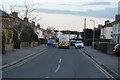
10
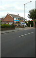
130, London Road
It appears that the house is being refurbished.
Image: © John Baker
Taken: 18 Oct 2020
0.13 miles