IMAGES TAKEN NEAR TO
Mill Road, DEAL, CT14 9AA
Introduction
This page details the photographs taken nearby to Mill Road, CT14 9AA by members of the Geograph project.
The Geograph project started in 2005 with the aim of publishing, organising and preserving representative images for every square kilometre of Great Britain, Ireland and the Isle of Man.

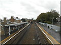
There are currently over 7.5m images from over14,400 individuals and you can help contribute to the project by visiting https://www.geograph.org.uk
Image Map
Images are licensed for reuse under creativecommons.org/licenses/by-sa/2.0
Notes
- Clicking on the map will re-center to the selected point.
- The higher the marker number, the further away the image location is from the centre of the postcode.
Image Listing (254 Images Found)
Images are licensed for reuse under creativecommons.org/licenses/by-sa/2.0
Image
Details
Distance
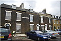
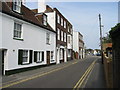
1
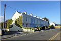
Terrace on Mill Road
A grade II listed building, from about 1840.
Image: © Robin Webster
Taken: 14 Oct 2017
0.01 miles
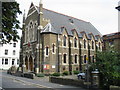
2
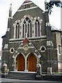
The front of Victoria Baptist Church on Victoria Road
Image: © Nick Smith
Taken: 17 Sep 2008
0.06 miles
3
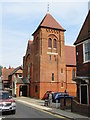
Catholic church of St Thomas of Canterbury
On Blenheim Road, Deal
Image: © Nick Smith
Taken: 17 Sep 2008
0.07 miles
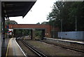
5
An Empty station
Mid September finds Deal station almost empty due to Covid 19 restrictions.
Image: © Anthony Vosper
Taken: 23 Sep 2020
0.07 miles
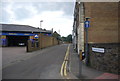
8
Albion Place
A terrace of houses outside Deal Station.
Image: © N Chadwick
Taken: 28 Aug 2011
0.08 miles
10
Looking N along Blenheim Road to Queen Street
Image: © Nick Smith
Taken: 17 Sep 2008
0.09 miles