IMAGES TAKEN NEAR TO
Sutton Road, DEAL, CT14 8JA
Introduction
This page details the photographs taken nearby to Sutton Road, CT14 8JA by members of the Geograph project.
The Geograph project started in 2005 with the aim of publishing, organising and preserving representative images for every square kilometre of Great Britain, Ireland and the Isle of Man.

There are currently over 7.5m images from over14,400 individuals and you can help contribute to the project by visiting https://www.geograph.org.uk
Image Map
Images are licensed for reuse under creativecommons.org/licenses/by-sa/2.0
Notes
- Clicking on the map will re-center to the selected point.
- The higher the marker number, the further away the image location is from the centre of the postcode.
Image Listing (47 Images Found)
Images are licensed for reuse under creativecommons.org/licenses/by-sa/2.0
Image
Details
Distance
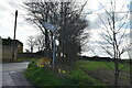
4
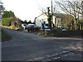
Ripple village hall
On junction of Pommeus and Sutton Lanes
Image: © Nick Smith
Taken: 16 Dec 2007
0.07 miles
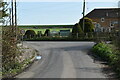
6
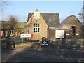
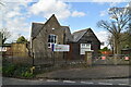
Ripple School RIP
The smallest primary school in Kent, which fought off the threat of closure two years ago (2004), has now failed to stop a renewed bid to shut it down.
The Ripple School, near Deal, will close for good as of 31 August (2007).
Image: © Nick Smith
Taken: 16 Dec 2007
0.07 miles
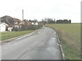
8
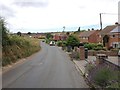
Houses on Vale Road and Sutton Lane
The houses on the right are on Sutton Lane and the others are on Vale Road, taken from Pommeus Lane.
Image: © Nick Smith
Taken: 12 Jan 2008
0.08 miles