IMAGES TAKEN NEAR TO
Ripple, DEAL, CT14 8HX
Introduction
This page details the photographs taken nearby to CT14 8HX by members of the Geograph project.
The Geograph project started in 2005 with the aim of publishing, organising and preserving representative images for every square kilometre of Great Britain, Ireland and the Isle of Man.

There are currently over 7.5m images from over14,400 individuals and you can help contribute to the project by visiting https://www.geograph.org.uk
Image Map
Images are licensed for reuse under creativecommons.org/licenses/by-sa/2.0
Notes
- Clicking on the map will re-center to the selected point.
- The higher the marker number, the further away the image location is from the centre of the postcode.
Image Listing (13 Images Found)
Images are licensed for reuse under creativecommons.org/licenses/by-sa/2.0
Image
Details
Distance
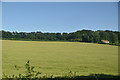
2
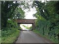
Railway Bridge over Wingleton Lane, near Ripple
Image: © Chris Whippet
Taken: 3 Aug 2016
0.11 miles
3
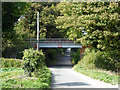
Railway bridge over Sutton Lane
The Dover - Thanet line has a 11'-6" clearance over the road.
Image: © Robin Webster
Taken: 14 Oct 2017
0.12 miles
4
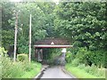
View along Sutton Lane under the railway bridge
Image: © Nick Smith
Taken: 4 Jul 2007
0.12 miles
5
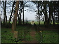
Footpath to Ripple
This path leads from Sutton Lane, near Ripple Court, through a small woodland beside the court towards Crooked S Road.
Image: © David Anstiss
Taken: 27 Mar 2011
0.15 miles
7
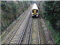
Deal bound train
Taken from the bridge on Ripple Road
Image: © Nick Smith
Taken: 13 Jan 2008
0.18 miles
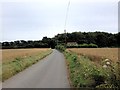
10
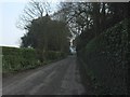
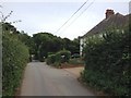
Sutton Lane near Ripple Court
Sutton Lane leads from Sutton, past the hedge surrounded house towards Ringwould.
Image: © David Anstiss
Taken: 27 Mar 2011
0.22 miles