IMAGES TAKEN NEAR TO
Ripple, DEAL, CT14 8HA
Introduction
This page details the photographs taken nearby to CT14 8HA by members of the Geograph project.
The Geograph project started in 2005 with the aim of publishing, organising and preserving representative images for every square kilometre of Great Britain, Ireland and the Isle of Man.

There are currently over 7.5m images from over14,400 individuals and you can help contribute to the project by visiting https://www.geograph.org.uk
Image Map
Images are licensed for reuse under creativecommons.org/licenses/by-sa/2.0
Notes
- Clicking on the map will re-center to the selected point.
- The higher the marker number, the further away the image location is from the centre of the postcode.
Image Listing (34 Images Found)
Images are licensed for reuse under creativecommons.org/licenses/by-sa/2.0
Image
Details
Distance
2
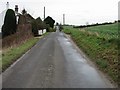
View along the Ripple Road towards the A258
Image: © Nick Smith
Taken: 13 Jan 2008
0.05 miles
3
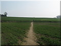
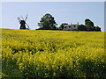
Bridleway to footpath junction on Ripple Road
A short bridleway leads from Ringwould Road, towards Ripple Road, then two paths lead up hill. The path on the left leads towards Ripple Windmill and the path on the right leads to Ringwould.
Image: © David Anstiss
Taken: 27 Mar 2011
0.08 miles
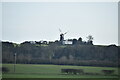
4
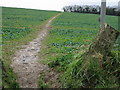
Footpath to Ringwould from the Ripple Road
Image: © Nick Smith
Taken: 13 Jan 2008
0.11 miles
5
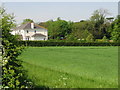
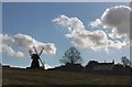
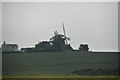
Ripple Mill
Restored smock mill off Dover Road. Viewed from Ripple Road.
Image: © Oast House Archive
Taken: 24 Jul 2010
0.11 miles
10
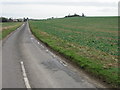
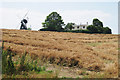
Looking NE along the Ripple Road
The mill in TR3649 can be seen on the horizon.
Image: © Nick Smith
Taken: 13 Jan 2008
0.12 miles