IMAGES TAKEN NEAR TO
The Leas, DEAL, CT14 8EW
Introduction
This page details the photographs taken nearby to The Leas, CT14 8EW by members of the Geograph project.
The Geograph project started in 2005 with the aim of publishing, organising and preserving representative images for every square kilometre of Great Britain, Ireland and the Isle of Man.

There are currently over 7.5m images from over14,400 individuals and you can help contribute to the project by visiting https://www.geograph.org.uk
Image Map
Images are licensed for reuse under creativecommons.org/licenses/by-sa/2.0
Notes
- Clicking on the map will re-center to the selected point.
- The higher the marker number, the further away the image location is from the centre of the postcode.
Image Listing (83 Images Found)
Images are licensed for reuse under creativecommons.org/licenses/by-sa/2.0
Image
Details
Distance
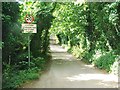
2
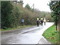
Learner drivers on Oldstairs Road
There are quite a few horse riding schools in this area
Image: © Nick Smith
Taken: 24 Feb 2007
0.09 miles
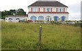
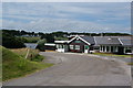
4
Walmer and Kingsdown Golf Course
The club house of Walmer and Kingsdown Golf Course.
Image: © Philip Halling
Taken: 18 Jul 2009
0.12 miles
5
The clubhouse of Walmer and Kingsdown Golf Club
The course occupies a large area of cliff top to the south of Kingsdown and to the south of here. There is camping in the field beyond.
Image: © Bill Boaden
Taken: 30 Jun 2012
0.12 miles
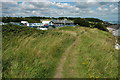
6
![A walk from St Margaret?s at Cliffe to Kingsdown and return [18]](https://s2.geograph.org.uk/geophotos/07/08/56/7085638_cbf8de62_120x120.jpg)
A walk from St Margaret?s at Cliffe to Kingsdown and return [18]
Seen from the path is the car park and clubhouse of the Walmer and Kingsdown Golf Club.
Starting from the Dover Patrol Monument, the walk follows the long distance Saxon Shore Way along the top of the cliffs before descending to the bay at Kingsdown. Heading inland there is an ascent of Wood Hill before various rights of way run across fields to the wonderfully named Otty Bottom, then on to Free Down and a return to the starting point. A little more than 5 miles.
Image: © Michael Dibb
Taken: 12 Sep 2021
0.12 miles
7
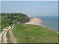
Saxon Shore Way to Kingsdown (2)
The long distance path leads from St.Margaret's Bay towards Kingsdown, via a coastal path. On the right are large houses alongside The Leas.
In the background is the shingle beach near Kingsdown.
Image: © David Anstiss
Taken: 24 Apr 2011
0.12 miles
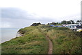

10
![A walk from St Margaret?s at Cliffe to Kingsdown and return [17]](https://s1.geograph.org.uk/geophotos/07/08/56/7085637_a2ec33a6_120x120.jpg)
A walk from St Margaret?s at Cliffe to Kingsdown and return [17]
As the path starts to descend, the view towards Kingsdown opens up.
Starting from the Dover Patrol Monument, the walk follows the long distance Saxon Shore Way along the top of the cliffs before descending to the bay at Kingsdown. Heading inland there is an ascent of Wood Hill before various rights of way run across fields to the wonderfully named Otty Bottom, then on to Free Down and a return to the starting point. A little more than 5 miles.
Image: © Michael Dibb
Taken: 12 Sep 2021
0.13 miles