IMAGES TAKEN NEAR TO
Upper Street, DEAL, CT14 8EU
Introduction
This page details the photographs taken nearby to Upper Street, CT14 8EU by members of the Geograph project.
The Geograph project started in 2005 with the aim of publishing, organising and preserving representative images for every square kilometre of Great Britain, Ireland and the Isle of Man.

There are currently over 7.5m images from over14,400 individuals and you can help contribute to the project by visiting https://www.geograph.org.uk
Image Map (Loading...)


Getting Data...Please wait
Leaflet Map data © OpenStreetMap
Images are licensed for reuse under creativecommons.org/licenses/by-sa/2.0
Notes
- Clicking on the map will re-center to the selected point.
- The higher the marker number, the further away the image location is from the centre of the postcode.
Image Listing (139 Images Found)
Images are licensed for reuse under creativecommons.org/licenses/by-sa/2.0
Image
Details
Distance
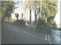
1
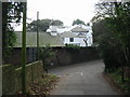
Junction of Church Cliff and Upper Street, Kingsdown
Image: © Nick Smith
Taken: 27 Dec 2008
0.01 miles
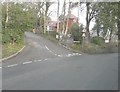
2
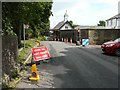
Traffic control on Upper Road
The road’s width has been reduced to one lane, due to the scaffolding on the side of The Bell Tower.
Image: © John Baker
Taken: 13 Jul 2014
0.02 miles
4
Swedish Whitebeam, Kingsdown Kent
Swedish Whitebeam (Sorbus intermedia) is a non-native relative of the Whitebeam and Rowan. The leaves appear intermediate between these two, hence the name. Although it is widely planted, I have never seen such a profusion of ripe fruit as here.
Image: © John Rostron
Taken: 20 Sep 2009
0.03 miles
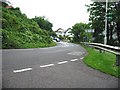
5
Land adjacent to Morning Glory, Church Cliff, Kingsdown
Planning permission has been granted by Dover District Council under application number DOV/11/00585 for the “erection of a detached dwelling and construction of a vehicular access”. Church Cliff is seen here at its junction with Upper Street.
Image: © John Baker
Taken: 16 Dec 2012
0.03 miles
6
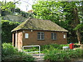
Kingsdown Toilets
Beside Undercliffe Road.
Image: © David Anstiss
Taken: 24 Apr 2011
0.03 miles
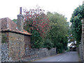
7
Signal House, Church Cliff, Kingsdown
It was yet to be built when I photographed the site on 16 December 2012 Image
Image: © John Baker
Taken: 27 Jan 2014
0.04 miles
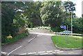
10
Undercliffe Road, Kingsdown
This road leads from Cliffe Road towards Oldstairs Road.
This is used by National Cycle Network 1 leading from Kingsdown to St Margaret's Bay.
Image: © David Anstiss
Taken: 17 Apr 2011
0.04 miles