IMAGES TAKEN NEAR TO
Granville Road, DEAL, CT14 8EL
Introduction
This page details the photographs taken nearby to Granville Road, CT14 8EL by members of the Geograph project.
The Geograph project started in 2005 with the aim of publishing, organising and preserving representative images for every square kilometre of Great Britain, Ireland and the Isle of Man.

There are currently over 7.5m images from over14,400 individuals and you can help contribute to the project by visiting https://www.geograph.org.uk
Image Map
Images are licensed for reuse under creativecommons.org/licenses/by-sa/2.0
Notes
- Clicking on the map will re-center to the selected point.
- The higher the marker number, the further away the image location is from the centre of the postcode.
Image Listing (20 Images Found)
Images are licensed for reuse under creativecommons.org/licenses/by-sa/2.0
Image
Details
Distance
1
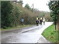
Learner drivers on Oldstairs Road
There are quite a few horse riding schools in this area
Image: © Nick Smith
Taken: 24 Feb 2007
0.12 miles


9
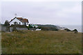
Clifftop houses near Oldstairs Bay
These houses command a fine view east across the eastern approaches of the Dover straits. The foreground is the land around the clifftop walk (Kingsdown Leas). In the distance (right of centre, east) is Kingsdown.
Image: © John Rostron
Taken: 20 Sep 2009
0.21 miles