IMAGES TAKEN NEAR TO
The Rise, DEAL, CT14 8AY
Introduction
This page details the photographs taken nearby to The Rise, CT14 8AY by members of the Geograph project.
The Geograph project started in 2005 with the aim of publishing, organising and preserving representative images for every square kilometre of Great Britain, Ireland and the Isle of Man.

There are currently over 7.5m images from over14,400 individuals and you can help contribute to the project by visiting https://www.geograph.org.uk
Image Map
Images are licensed for reuse under creativecommons.org/licenses/by-sa/2.0
Notes
- Clicking on the map will re-center to the selected point.
- The higher the marker number, the further away the image location is from the centre of the postcode.
Image Listing (125 Images Found)
Images are licensed for reuse under creativecommons.org/licenses/by-sa/2.0
Image
Details
Distance
2
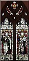
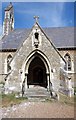
St John the Evangelist, Kingsdown, Kent - Window
Image: © John Salmon
Taken: 8 Sep 2009
0.05 miles
3
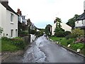
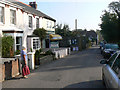
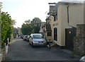
Upper Street, Kingsdown
Looking ENE towards the sea.
Image: © Nick Smith
Taken: 4 Jul 2007
0.05 miles
4
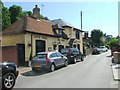
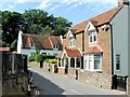
Upper Street, Kingsdown, and the King's Head pub
Image: © Nick Smith
Taken: 4 Jul 2007
0.05 miles
5
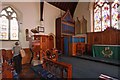
St John the Evangelist, Kingsdown, Kent - Sanctuary
Image: © John Salmon
Taken: 8 Sep 2009
0.05 miles
6
Village newsagent and store, Kingsdown
One of the four shops in Kingsdown village street.
Image: © John Rostron
Taken: 19 Sep 2009
0.05 miles
9
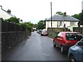
The King's Head pub, Kingsdown
Looking east-north-east along the village street. This has a handful of shops and this pub.
Image: © John Rostron
Taken: 19 Sep 2009
0.06 miles
10
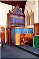
St John the Evangelist, Kingsdown, Kent - Organ
Image: © John Salmon
Taken: 8 Sep 2009
0.06 miles