IMAGES TAKEN NEAR TO
Hawkshill Lane, DEAL, CT14 7TU
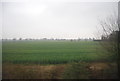
Introduction
This page details the photographs taken nearby to Hawkshill Lane, CT14 7TU by members of the Geograph project.
The Geograph project started in 2005 with the aim of publishing, organising and preserving representative images for every square kilometre of Great Britain, Ireland and the Isle of Man.

There are currently over 7.5m images from over14,400 individuals and you can help contribute to the project by visiting https://www.geograph.org.uk
Image Map
Images are licensed for reuse under creativecommons.org/licenses/by-sa/2.0
Notes
- Clicking on the map will re-center to the selected point.
- The higher the marker number, the further away the image location is from the centre of the postcode.
Image Listing (71 Images Found)
Images are licensed for reuse under creativecommons.org/licenses/by-sa/2.0
Image
Details
Distance
1
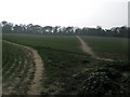
Footpath and bridleway junction near Mayers Road
A bridleway heads from Mayers Road towards Ripple Road.
A footpath heads straight on towards Coldblow Lane near Coldblow Farm.
Image: © David Anstiss
Taken: 27 Mar 2011
0.09 miles
2
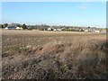
Land off Station Road, Walmer, CT14 7RH
Planning permission has been granted by Dover District Council under application number DOV/14/00361 for the “erection of 223 dwellings (including 66 affordable units) together with associated vehicular access, car parking, landscaping, and open space (amended plans)”. The houses, on the left hand side of the view, are in Mayers Road, which is mentioned in the application. The local newspapers have reported a furious outburst from nearby residents, especially those living on the caravan site, which will overlook the new housing.
Image: © John Baker
Taken: 13 Dec 2014
0.10 miles
4
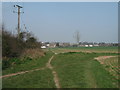
Footpath and bridleway junction near Coldblow Farm
A bridleway leads from Ripple Road straight on towards Mayers Road in Walmer. A footpath heads right towards Dover Road, or left to Coldblow Lane.
Image: © David Anstiss
Taken: 27 Mar 2011
0.13 miles
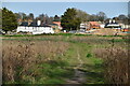
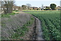
5
Footpath to Dover Road
This path leads from Coldblow Road, past Clifford Park Caravan Site towards the A258 Road.
Image: © David Anstiss
Taken: 17 Apr 2011
0.13 miles
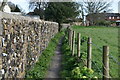
6
Footpath to Station Road
A path leads from Coldblow Lane towards the road in Walmer.
Image: © David Anstiss
Taken: 27 Mar 2011
0.13 miles