IMAGES TAKEN NEAR TO
Downs Road, DEAL, CT14 7TN
Introduction
This page details the photographs taken nearby to Downs Road, CT14 7TN by members of the Geograph project.
The Geograph project started in 2005 with the aim of publishing, organising and preserving representative images for every square kilometre of Great Britain, Ireland and the Isle of Man.

There are currently over 7.5m images from over14,400 individuals and you can help contribute to the project by visiting https://www.geograph.org.uk
Image Map
Images are licensed for reuse under creativecommons.org/licenses/by-sa/2.0
Notes
- Clicking on the map will re-center to the selected point.
- The higher the marker number, the further away the image location is from the centre of the postcode.
Image Listing (15 Images Found)
Images are licensed for reuse under creativecommons.org/licenses/by-sa/2.0
Image
Details
Distance
2
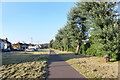
Cycleway, Telegraph Road
On the wide grass verge between the road and railway.
Image: © Des Blenkinsopp
Taken: 12 Jun 2021
0.11 miles


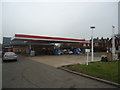
6
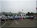
Adamson's Skoda car dealership, Walmer
Image: © Stacey Harris
Taken: 17 Feb 2012
0.17 miles
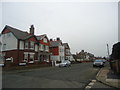
7
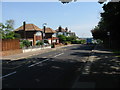
Looking NE along Telegraph Road
Taken from the junction with St Richard's Road
Image: © Nick Smith
Taken: 11 May 2008
0.17 miles